Conceptualising bushfire-ecosystem relationships
Bushfires play a fundamental role in shaping many Australian landscapes. They can also have significant impacts on terrestrial and aquatic ecosystems, particularly when there is an increase in sediment, nutrients, and contaminants entering waterways from fire-impacted areas.
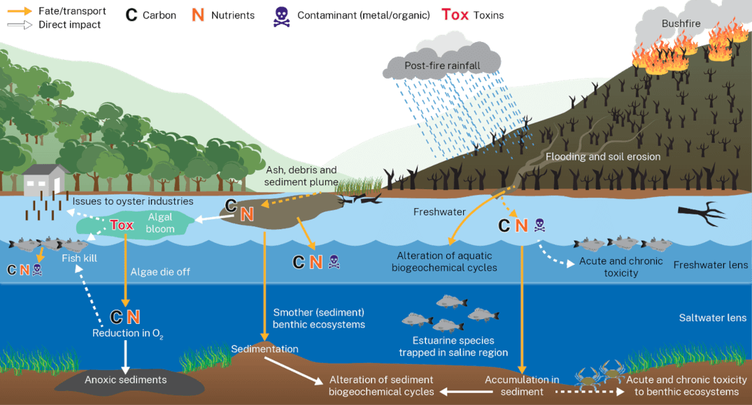
Figure 1 presents a conceptual model of bushfire impacts on aquatic ecosystems. This model explains the connection between catchments and waterways, and how bushfires can potentially affect water quality and the health of aquatic ecosystems.

Figure 1: Conceptual model outlining the potential implications of bushfires on aquatic ecosystems based on available scientific literature and data collected to date
Investigating impacts from NSW bushfires on water quality
1. Indicators of bushfire impacts on aquatic systems
Short-term decrease in dissolved oxygen levels, lasting from days to weeks. This is attributed to elevated levels of organic matter decomposition in waterways post-bushfires. Reduced oxygen can stress and threaten aquatic organisms, potentially resulting in fish kills.
Elevated turbidity and reduced water clarity caused by elevated sediment and debris input from burned, eroding catchments. Increased turbidity levels can reduce photosynthesis due to reduced light penetration through the water column, obstruct fish gills, and smother sediment ecosystems.
Increased levels of nitrogen and phosphorus in estuaries originating from burned soils and vegetation washed into waterways. These can trigger the formation of potentially harmful algal blooms.
Potential increase in algal blooms due to elevated levels of nutrients (nitrogen and phosphorus) and dissolved organic matter in estuaries post-fires.
You can view and download figures 2–5, with graphs showing the results of the research on bushfire impacts.
2. What do these findings tell us so far?
The data collected in estuaries along the NSW south coast before, during, and after the 2019–20 Black Summer bushfires has provided valuable insights into the short-, medium- and long-term water quality impacts.
- Early findings suggest that water quality changes are greatest in intermittently closed and open lakes and lagoons (ICOLLs) compared to permanently open estuaries like rivers.
- This is attributed to the lower rate and amount of flushing with the ocean in open estuaries.
3. Conceptual models of pre- and post-bushfire impacts
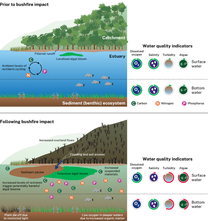
Informed by field data, Figure 6 shows anticipated changes in estuaries pre- and post-bushfires. Bushfires increase the amount of soil, ash and debris into waterways during rainfall events due to reduced vegetation and heightened soil hydrophobicity (tendency to repel water). As a result of these changes, water quality can be impacted, leading to:
- higher turbidity levels which can:
- reduce light available for photosynthesis (important process for aquatic plants)
- smother sedimentary (benthic) ecosystems during the settling of sediment and debris
- clog gills of fish and other aquatic organisms inducing stress and other impacts
- declines in dissolved oxygen – increased organic matter entering waterways triggers increases in microbial activity which reduces dissolved oxygen levels in ecosystems
- nutrient effects – elevated nutrient concentrations post-fire can trigger the formation of potentially harmful algal blooms
- algal bloom consequences – algal blooms may produce toxins harmful to aquatic organisms and human health
- longer-term impacts – decaying algal blooms release nutrients to the water column, fuelling further blooms that result in greater oxygen depletion.
Figure 6 illustrates the likely impacts of bushfires on water quality based on field data collected to date.

Figure 6: Model illustrating the impacts of bushfires on water quality based on field data collected to date
Summer 2023: seasonal outlook for bushfire-driven water-quality risk
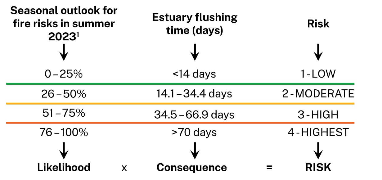
The Estuaries and Catchments team have been developing a water quality risk assessment for estuaries with a higher likelihood of fire in their catchment to help understand those waterways at risk of poor water quality. This preliminary assessment is informed by the Australasian Fire Authorities Council (AFAC) Summer 2023 bushfire outlook and considers the proportion of vegetation cover within catchments, and estuary ‘flushing-time’ data.
Figure 7 presents a high-level risk assessment of fire-related water quality impacts. These impacts may still occur in estuaries not assessed as high risk in this screening assessment. This process assists planning of ongoing water-quality monitoring to better understand the impacts of bushfires on waterways. The estuaries with the highest risk of water-quality issues related to bushfire impacts in summer 2023 are presented below. A more sophisticated risk-assessment tool is under development to better understand relative water-quality risks related to bushfire.

Figure 7: High-level risk assessment of fire-related water quality impacts
You can view and download maps of New South Wales showing an overview of the preliminary risk assessment method and categories for summer 2023. The seasonal outlook for summer 2023 considers the proportion of catchment that is forested and those areas with an increased fire risk.