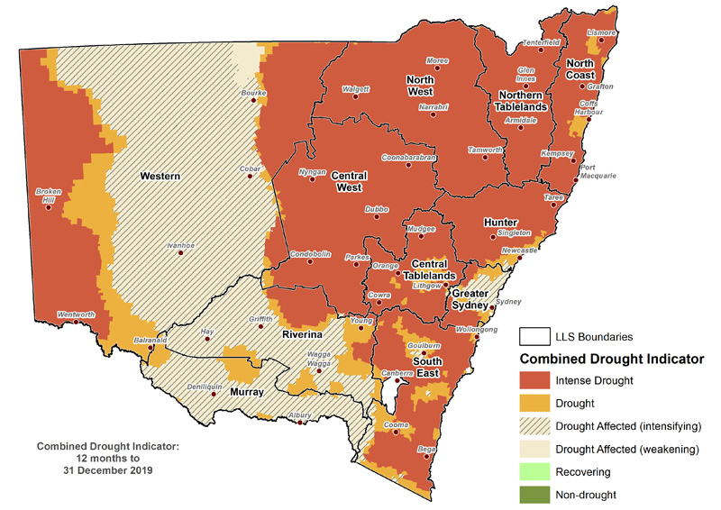
The Bureau of Meteorology reported 2019 was the warmest and driest year on record for Australia as a whole and for New South Wales. Australia’s average mean temperature in 2019 was 1.52 °C above average. Rainfall deficiencies across large parts of the country continued to increase, exacerbating drought and fire weather conditions.
Summer
Summer 2018–2019 was the warmest summer on record with very much below average rainfall across the northern two-thirds of the State. The State experienced several heatwave events and saw many records broken, with the statewide mean, minimum and maximum temperatures exceeding previous records by more than half of a degree.
Autumn
Autumn 2019 was the fourth-warmest autumn on record for NSW. Total rainfall for the State was 32% below the long-term autumn average, with scattered areas of above average totals particularly over the northwest.
Winter
Winter 2019 experienced the fourth-lowest total rainfall on record since 1982, 62% below average, and lowest rainfall on record for the northern inland parts of the State. The mean maximum temperature for the State was 1.44ºC above average and the fifth-warmest winter on record. Mean maximum temperatures were very much above average in the east, and record high in parts of the northeast of the State.
Spring
Spring 2019 was the sixth driest on record for the State, with rainfall around 61% below average and more than half of NSW recording very much below average rainfall. Above average daytime temperatures were seen across much of the State with temperatures typically more than 3°C above average over parts of the east. Minimum temperatures were very much below average across the south of the State. Heatwave conditions in late November brought the highest temperatures on record for some locations in the south. The warmest temperature for the season was recorded on 21 November, with a Statewide average of 39.4°C. New South Wales was 100% drought-declared in November (NSW Department of Primary Industry Combined Drought Indicator – November 2019).
December
December 2019 saw record high temperatures for the month and repeated bursts of very hot days. Some locations broke the existing highest daily maximum for December on multiple days. The State’s mean temperature for December was the highest on record, at 3.32°C above average, about 0.4°C warmer than the previous highest in 2018. December rainfall was 85% below average, the second lowest on record and the lowest since 1938. The NSW Department of Primary Industry’s Combined Drought Indicator showed 100% of NSW in drought in December. The record high temperatures, severe rainfall deficiencies and very low humidity brought nearly all of New South Wales its highest December Forest Fire Danger Index values.

Combined drought indicator, 12 months to 31 December 2109.