The Macquarie–Castlereagh valley covers more more than 91,000 square kilometres in the north of New South Wales. The catchment extends from the Blue Mountains to the Barwon River Plains, with major tributaries including the Cudgegong, Talbragar and Bell rivers.
The valley is home to the iconic Macquarie Marshes – one of the largest semi-permanent wetland systems and colonial waterbird breeding sites in inland Australia.
Key outcomes
The 2020–21 water year continued the recovery of the Macquarie–Castlereagh river system from the record drought that occurred from 2017 to 2020.
Water for the environment was used to boost natural flows to improve environmental recovery from August 2020 to March 2021. Key outcomes included:
- providing flows to support the breeding of Murray cod and freshwater catfish in the mid-Macquarie River
- the inundation of parts of the core of the Macquarie Marshes for vegetation and waterbirds to benefit the recovery of wetland vegetation.
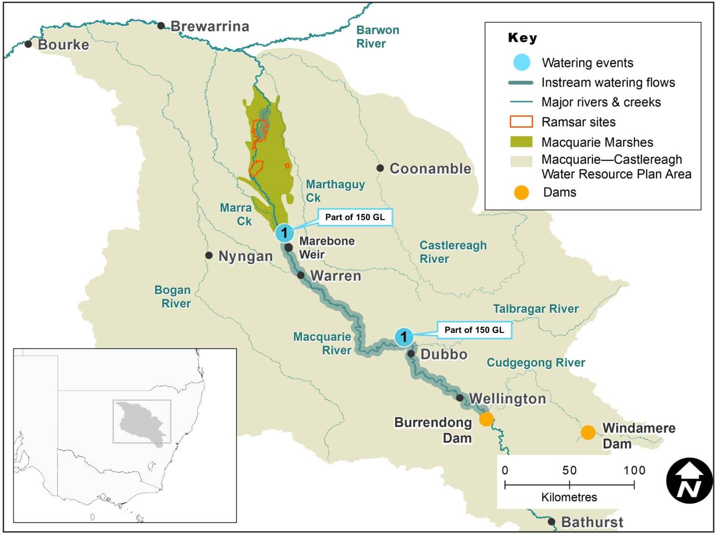
Macquarie-Castlereagh catchment area map
Watering aims
As discussed in the Macquarie–Castlereagh catchment: Annual environmental watering priorities 2020–21, the watering aims for the year were to ensure that core refuge pools and basic system components were maintained, with more water becoming available to improve drought recovery.
As water balances grew throughout the water year, the Department of Planning, Industry and Environment worked with the Commonwealth Environmental Water Holder and Macquarie-Cudgegong Environmental Water Advisory Group to develop adaptive strategies to maximise drought recovery.
Water delivery
This bar chart and table provide a summary of 150,730 megalitres of water for the environment use in the Macquarie–Castlereagh catchment during the 2020–21 watering year. Volumes are indicative only. The watering event number on the bar chart and in the table relates to the location number marked on the map.
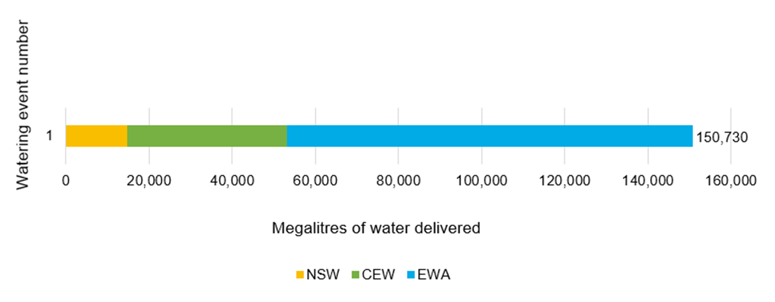
Water delivery to the Macquarie-Castlereagh catchment in 2020-21
| Watering event number | Location | Outcomes | Start date | Finish date |
|---|---|---|---|---|
| 1 | Macquarie Marshes | Connectivity Waterbirds Native fish Vegetation | 01 Aug 2020 | 26 Mar 2021 |
Notes: NSW = NSW licensed environmental water (general security and supplementary licences); CEW = Commonwealth licensed environmental water; EWA = Environmental water allowance accrued under the Water Sharing Plan for the Macquarie and Cudgegong Regulated Rivers Water Source 2016.
Outcomes
The drought-based priorities listed in the Macquarie–Castlereagh Catchment Annual Environmental Water Priorities 2020–21 were met as catchment inflows continued.
As water balances grew throughout the water year, the Department of Planning, Industry and Environment adapted its approach to maximise the environmental recovery though targeted actions.
Inundation of the Macquarie Marshes wetland system
Water for the environment helped inundate the inner Macquarie Marshes (19,000 hectares). This supported extensive areas of reedbed, mixed marsh and water couch meadows, and inner river red gum woodlands.
Contributions from environmental flows resulted in the inner 9000 hectares of the Marches experiencing inundation for 6 months between August 2020 and February 2021. This enabled vegetation recovery and seed set across many core areas.
Native fish breeding in the mid-Macquarie River
A stable flow of about 1000 megalitres per day in October in the mid-Macquarie River near Dubbo was built into the release strategy to support native fish breeding. These in-channel stable flow conditions were provided for specialist fish species that need specific habitat to nest. Other species expected to benefit from these conditions included native carp, gudgeon and unspecked hardyhead. Commonwealth Environmental Water Holder-funded surveys in March 2021, undertaken by Department of Primary Industries – Fisheries, indicated that Murray cod larvae generated during October 2020 had been recruited into the juvenile fish population.
Connectivity to the Barwon River
Environmental water contributed to the 41 gigalitres of flow measured downstream of the Macquarie Marshes at Miltara, on the Lower Macquarie. Some of this volume reached the Barwon River, enabling movement of fish between catchments and contributing to flows in the Barwon–Darling system.
Case study: Supporting recovery of native fish
The record drought of 2017–20 saw the regulated Macquarie River flows cut at Warren for the first time in more than 50 years. When flows returned to the Macquarie catchment in January–February 2020, the first flush from the bare catchment created a major fish kill event around Dubbo and downstream of Warren, further impacting an already struggling native fish population. This generated concerns about the survival of native fish populations, and native fish and freshwater turtle rescue efforts were conducted over the summer of 2019–20.
Providing flows to promote recovery of native fish populations was a key priority identified in the 3-year drought recovery plan prepared by the Macquarie–Cudgegong Environmental Water Advisory Group.
In year one of the plan, in the spring of 2020, a key aim of environmental flows was to support successful Murray cod nesting.
A flow target between 1000 and 2000 megalitres per day near Narromine was set for October 2020, followed by a flow pulse in November. This allowed:
- support for fish nesting
- important flows to the Macquarie Marshes downstream, which connected through to the Barwon River.
Natural tributary flows continued into September 2020 but reduced in October. Dam releases were needed to maintain the target flow rate. Without those releases, the river flows would have dropped and compromised cod nesting sites.
Commonwealth Environmental Water Holder-funded fish monitoring in the Macquarie River near Gin Gin and Trangie indicated that native fish and mussels bred successfully in the mid-Macquarie River upstream of monitoring locations. Survey results found:
- larvae of 4 fish species, Murray cod, freshwater catfish, golden perch, Australian smelt
- young yabbies and freshwater mussels
- Murray cod made up 88% of the larvae caught
- eggs of the endangered silver perch.
Further surveys in early 2021 indicated that Murray cod larvae had successfully grown into juvenile fish.
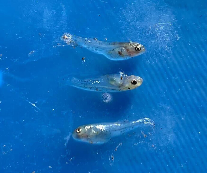
Three native larval fish