Covering an area of 81,527 square kilometres, the Murrumbidgee catchment includes 26 storage or diversion structures, along with a 1690-kilometre stretch of the river, and surrounding wetlands.
The Murrumbidgee catchment saw very dry conditions and significantly lower than average inflows in 2019–20. This resulted in only an 11% general security allocation (the average carryover was 8%) with about 30 gigalitres of New South Wales environmental water allowances available for use.
The focus of water managers in 2019–20, with an expected very dry to dry resource availability scenario as identified in the Murrumbidgee Catchment Annual Environmental Watering Priorities 2019–20, was aimed at restoring a more normal flow pattern to support a robust food web and other system functions. These dry conditions continued until early 2020 when wetter than expected conditions occurred.
Maintaining habitat
To build on low starting allocations, water was carried over from the 2018–19 water year. Under these conditions, the Department of Planning, Industry and Environment environmental water managers worked with the Commonwealth Environmental Water Holder (CEWH) to water the Gayini (Nimmie-Caira) wetlands, located in the Lowbidgee region. This private property event inundated thousands of hectares of lignum wetlands and creeks, which in wetter times provide important nesting habitat for colonial waterbirds such as spoonbills and ibis.
Remaining water for the environment was used to maintain refuge habitats for native fish, frogs and turtles as well as habitat important to waterbird species such as Australasian bitterns and brolgas. Significant outcomes included:
- improved condition of wetland vegetation communities in the Lower Murrumbidgee
- improved fish habitat during low flows and heat-wave conditions
- southern bell frog recolonisation
- Australasian bittern breeding (Campbells swamp)
- maintenance of brolga habitat (Tuckerbil and Wanganella swamps)
- some colonial waterbird breeding (Eulimbah, Yarradda, Gooragool).
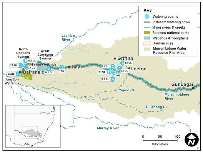
Murrumbidgee catchment area map
Watering aims
After a successful large-scale watering of Yanga National Park in 2018–19, plans were put in place to use water for the environment primarily in the Gayini and North Redbank systems of the Lowbidgee Floodplain.
Water for the environment was also set aside specifically to manage higher flows for native fish habitat requirements, should a repeat of the record heat wave conditions and low flows eventuate during the summer of 2019–20.
The Murrumbidgee Environmental Water Advisory Group considered the condition of river and wetland assets, water availability and weather forecasts and recommended flows to support a range of ecological outcomes. The main aims of the flows were to:
- use existing infrastructure to provide water to the wetlands of the Lowbidgee Floodplain
- support habitat for the threatened southern bell frog
- encourage the ongoing recovery of native wetland plants to provide habitat, feeding and breeding opportunities for a range of native animals
- provide foraging and breeding opportunities for waterbirds including bitterns
- replenish wetland refuges in anticipation of possible dry times in the future.
The watering aims identified in the Murrumbidgee Catchment Annual Environmental Watering Priorities for the 2019–20 water year were largely implemented as proposed under the very dry to dry conditions.
Water delivery
This bar chart and table provide a summary of 80,493 megalitres of water for the environment delivered in the Murrumbidgee catchment during the 2019–20 watering year. Volumes are indicative only. Watering event numbers in the bar chart and table relate to location numbers marked on the map.
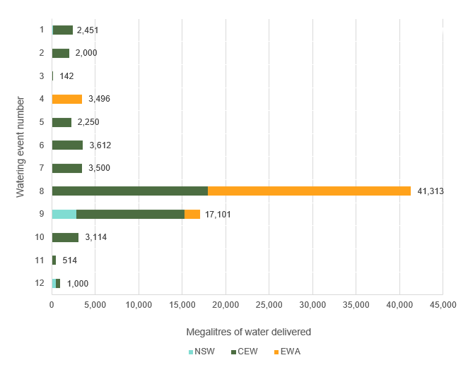
Bar chart showing water delivery to the Murrumbidgee catchment in the 2019–20 water year.
Notes: NSW = NSW licensed environmental water; CEW = Commonwealth licensed environmental water; EWA = Environmental water allowance accrued under the Water Sharing Plan for the Murrumbidgee Regulated River Water Source 2016.
| Watering event number | Location | Outcomes | Start date | Finish date |
|---|---|---|---|---|
| 1 | Gooragool and Mantangry lagoons | Native fish | 09 Sep 2019 | 16 Jan 2020 |
| 2 | Yarradda Lagoons pumping | Native fish Waterbirds Vegetation | 18 Sep 2019 | 10 Dec 2019 |
| 3 | Darlington Lagoon | Native fish Vegetation | 19 Sep 2019 | 27 Sep 2019 |
| 4 | Coleambally Irrigation Area Wetlands | Waterbirds | 10 Oct 2019 | 30 Jan 2020 |
| 5 | Wanganella Swamp | Waterbirds Vegetation | 13 Oct 2019 | 28 Jan 2020 |
| 6 | Murrumbidgee Irrigation Area | Waterbirds | 14 Oct 2019 | 15 Apr 2020 |
| 7 | Lower Murrumbidgee pumping | Waterbirds Vegetation | 21 Oct 2019 | 23 Jan 2020 |
| 8 | Gayini Nimmie-Caira refuge flows | Waterbirds | 28 Oct 2019 | 05 Jan 2020 |
| 9 | North Redbank Wetland | Waterbirds Vegetation | 26 Nov 2019 | 04 Jan 2020 |
| 10 | Yanga National Park | Waterbirds Vegetation | 29 Nov 2019 | 18 Dec 2019 |
| 11 | Sunshower Lagoon | Waterbirds | 01 Dec 2019 | 27 Jan 2020 |
| 12 | Toogimbie Rookery Wetland | Waterbirds | 24 Feb 2020 | 07 Jun 2020 |
Outcomes
In partnership with the Murrumbidgee Environmental Water Advisory Group and the Commonwealth Environmental Water Holder, Department of Planning, Industry and Environment environmental water managers delivered much of the available water for the environment to the Lowbidgee Floodplain, primarily to wetland systems in Gayini (Nimmie-Caira) and North Redbank.
This water:
- triggered large scale southern bell frog recruitment events in the Gayini and Nap Nap wetlands
- initiated and maintained small spoonbill, ibis, darter and cormorant rookeries in the Gayini, Yarradda and Gooragool wetlands
- provided refuge and breeding opportunities for Australasian and little bitterns at numerous wetlands including Campbells Swamp, Mainie Swamp and McCaugheys Lagoon.
Sunshower Lagoon near Darlington Point, which was hard-hit by the Millennium Drought, began its road to recovery with managed flows dramatically improving the condition of wetland vegetation including river red gums, spike rush, water ribbons and water lilies. Pumped delivery of water for the environment via a local contractor eliminated carp, which maximised the aquatic vegetation and frog response. Southern bell frogs were heard calling at the site for the first time in a decade.
These outcomes achieved the key planned actions proposed for the 2019–20 water year.
Case study
The restoration of Sunshower Lagoon has been a highlight of the Murrumbidgee watering year.
For the first time, water managers used new infrastructure to deliver water for the environment to the site. The infrastructure was co-funded by the Department of Planning, Industry and Environment (DPIE) and Riverina Local Land Services under the Boosting the Bunyip Bird Project.
DPE managed the delivery of 514 megalitres of Commonwealth environmental water to the site between the start of December 2019 and the end of January 2020.
The site had been dry since 2016 and was severely drought stressed.
River red gums were the first to bounce back after water arrived. Aquatic plants followed soon after with common rush, spike rush and water ribbon appearing in encouraging numbers and setting seed in response to the flow.
Monitoring of the flow detected the presence of endangered southern bell frogs that had not been seen or heard at the site since 2010.
A combination of factors are thought to have contributed to the success of the watering event, including timing.
The watering occurred after the carp spawning period meaning fewer small carp were present in the system. The use of carp screens further reduced the number of carp present which, in turn, reduced pressure on recovering wetland plants.
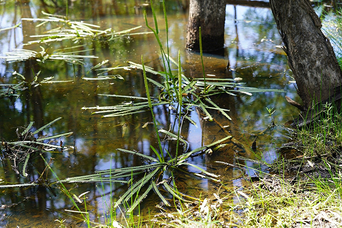
Vegetation response at Sunshower Lagoon