Key outcomes
Continuation of natural flooding, rainfall, tributary inflows and daily operational dam water releases met environmental demands in the Namoi system in 2022–23. Environmental water managers adopted a ‘watching brief’ to identify whether intervention with environmental flows would be required. The objective of flow management was to:
- inundate floodplain and anabranch wetlands downstream of Keepit Dam to Walgett
- allow unrestricted fish passage along the Namoi and Peel rivers
- support recruitment and movement of golden perch and other flow-specialist native fish
- provide connectivity between the Peel, Namoi and Barwon rivers.

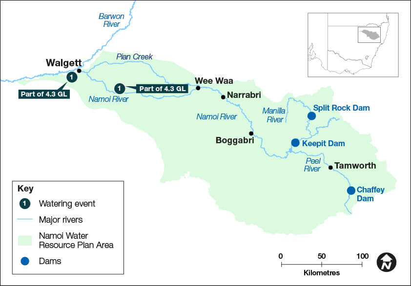
Map of the Namoi catchment showing waterways, wetlands and locations of water for the environment deliveries made in 2022-23.
Catchment conditions
During 2022–23, the Peel–Namoi catchment continued to experience very wet conditions driven by a well-developed La Niña event. This resulted in large-scale flooding and generally cool summer temperatures.
Keepit, Split Rock and Chaffey dams remained at 100% storage capacity for the majority of the year. All 3 storages spilled water throughout the year, providing warmer ambient water temperatures and mirrored natural rises and falls in river heights downstream of each storage.
General security allocations reached 200% in the Lower Namoi, and 100% in the Manilla and Peel, as well as 100% allocation in the Chaffey Environmental Water Allowance.
These changing circumstances heavily influenced the watering approach and outcomes sought. Environmental water managers adapted their watering plans in response to catchment conditions and changing environmental needs.
About the catchment
The Namoi catchment is in northern NSW and covers an area of 42,000 square kilometres. Located in a temperate climate zone, rainfall typically occurs in summer. The major regulated rivers are the Namoi and Peel, with major water storages at Keepit, Split Rock and Chaffey dams. The Namoi River flows into the Barwon River at Walgett.
The lower Namoi catchment is a highly modified landscape. Remnant wetlands are present along the floodplain anabranches downstream of Narrabri, known locally as warrambools. These provide important habitat for waterbirds and nursery areas for native fish. The Namoi and Peel rivers support native fish including Murray cod, silver perch and freshwater catfish.
The Namoi River between Gunnedah and Narrabri provides important habitat for critically endangered silver perch. Lake Goran, in the unregulated Mooki catchment, is listed as a wetland of national significance, and provides habitat for waterbirds when inundated.
The Namoi River is the second largest contributor of flow into the Barwon River, providing an important source of water and opportunities for the movement and survival of native fish.
Water for Country
The Namoi is Country to the Gomeroi/Kamilaroi Aboriginal peoples.
Water for Country is environmental water use planned by the Department of Planning and Environment and Aboriginal people to achieve shared benefits for the environment and cultural places, values and/ or interests.
Watering aims
Under a wet to very wet resource availability scenario, environmental water managers and their delivery partners identified water use objectives in the Annual environmental water priorities in the Namoi catchment 2022–23, which were to:
- continue drought recovery of native fish populations in the Peel and Lower Namoi rivers
- provide a low flow connection with the Lower Namoi and Barwon River
- provide a ‘small fresh’ in the Peel River during spring to promote instream productivity and fish movement opportunities.
With favourable catchment conditions and significant inflows persisting throughout the year, environmental water managers adopted a ‘watching brief’ to identify whether intervention with water for the environment would be required to support assets or objectives.
Water delivery
This table and chart provide a summary of 4,320 megalitres (ML) of water for the environment delivered in the Namoi catchment during the 2022–23 watering year.
Persistent tributary inflows, combined with spills from Keepit and Chaffey dams, met environmental water demands in the Peel and Lower Namoi rivers during 2022–23.
The natural rainfall inflows, coupled with warm surface water release over the storage spillways, delivered ideal support to riverine and floodplain assets throughout the year.
In the Namoi, 4.3 gigalitres of Commonwealth water for the environment was delivered between April and May 2023. This water was delivered as a small fresh to the lower Namoi River as part of the ‘Northern Refresh Flow’ event to maintain connection with the Barwon-Darling.
Figures were accurate at the date of publishing, but may be adjusted. Watering event numbers in the table and bar chart relate to location numbers marked on the map.

Notes: CEW = Commonwealth licensed environmental water; EWA = environmental water allowance accrued under the Water Sharing Plan; NSW = NSW licensed environmental water; TLM = The Living Murray.
| Watering event number | Location | Outcomes | Start date | Finish date |
|---|---|---|---|---|
| 1 | Northern Refresh Flow | Connectivity Native fish | 18 Apr 2023 | 21 May 2023 |
Outcomes
In 2022–23, environmental water managers planned to adaptively manage available water for the environment to support drought recovery in the Namoi and Peel rivers. However, natural flows met environmental demands in the Peel River and water for the environment was not required.
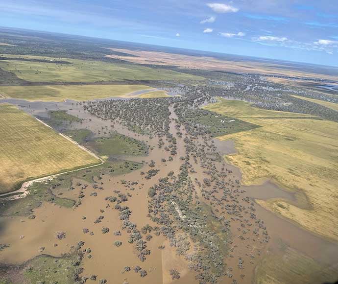
Natural floods provided significant environmental benefits as they inundated water-dependent assets well beyond the capacity of state and Commonwealth environmental water holdings.
As part of the Northern Refresh Flow event, 8.8 gigalitres (GL) of water for the environment was delivered from storages in the Gwydir (4.5 GL) and Namoi (4.3 GL) into the Barwon–Darling from April to mid-May to:
- improve water quality
- keep streams and rivers connected
- help native fish survive in the northern basin.
Water delivered to the lower Namoi River helped to refresh and improve water quality, increase connectivity to the Barwon River, and provide opportunities for native fish to move and survive.
Water quality monitoring showed that the amount of dissolved oxygen in the lower Namoi increased with the delivery of water for the environment, providing better conditions for native fish to survive.
A full 365 days of flow connectivity was observed between the Lower Namoi and Barwon rivers. This continuous flow provided an excellent opportunity for the dispersal and movement of native fish between the 2 river systems, including juvenile golden perch (yellow-belly), which had bred in the Barwon River. Flow conditions in the lower Namoi River between spring and mid-summer promoted breeding of golden and silver perch, although no formal monitoring was undertaken to confirm if breeding occurred in the Namoi.
The warrambools and river red gum/coolabah communities located on the higher floodplains, downstream of Narrabri, continued to receive prolonged periods of inundation over summer. This flooding will promote regeneration and improve resilience in these remnant vegetation communities.
In the Peel River, water spilled from Chaffey Dam and removed the accumulated sediment below the storage from the low flow river channel. This sediment removal, coupled with the mobilisation of organic matter from instream bars, helped improve the health and productivity within this section of the river. Improved productivity means more food for native fish, platypus, water rats and other water-dependent wildlife.
Case study - Rivers need large floods to move sediment
Large floods during the 2022–23 water year moved and cleared sediment and vegetation build up in the Peel and Namoi river channels.
Over time, fine sediments build up in our rivers from catchment runoff. This sediment fills the spaces between gravel and in some instances, smothers the entire bed with a layer of silt.
Sediment and vegetation can also build up during dry periods.
Too much sediment reduces the primary production capacity of our rivers, which is the basis of the food chain for our native fish, platypus and other water-dependent critters. Although larger flows and floodplain inundation events affect communities and infrastructure, they are critical to the natural cycling of rivers and the organisms they support.
Floods help refresh our rivers by flushing sediment from the riverbed back onto the floodplain to restore the primary production capacity needed for a healthy river environment.
From early 2021 to December 2023, widespread large-scale flooding provided high velocity flows and floodplain inundation in the Peel and Namoi rivers.
This contrasts to the previous 8 years of low to moderate flows, which allowed sediment to accumulate within the riverbed. Large flow events during the recent wet period, saw the Peel and Namoi rivers largely stripped and cleaned of sediment, leaf litter, grasses, shrubs and, in some cases, small trees from their beds and in-channel benches.

Large floods during the 2022–23 water year moved and cleared sediment and vegetation build up in the Peel and Namoi river channels.