Hastings River is located on the mid-north coast of New South Wales. It is a large barrier estuary with a permanently open, trained entrance.
The river and its estuary dominate the landscape and provide a focal point for Port Macquarie and surrounds. The Maria River and Limeburners Creek converge with the lower estuary; the latter supports extensive important wetlands and other significant habitats.
Water quality report card
As part of our water quality monitoring program we assess the water quality and ecosystem health of an estuary using a range of relevant indicators. We sample a subset of the estuaries located between the Queensland border and Taree every 3 years. The most recent sampling in the Hastings River was completed over the 2018–19 summer, when 2 sites were sampled on a monthly basis.
This report card represents 2 water quality indicators that we routinely measure: the amount of algae present and water clarity. Low levels of these 2 indicators equate with good water quality.
Algae
Water clarity
Overall grade
The report card shows the condition of the estuary was good with:
- algae abundance graded fair (C)
- water clarity graded good (B)
- overall estuary health graded good (B).
Grades for algae, water clarity and overall are represented as:
- A – excellent
- B – good
- C – fair
- D – poor
- E – very poor.
Go to estuary report cards to find out what each grade means, read our sampling, data analysis and reporting protocols, and find out how we calculate these grades.
Port Macquarie Hastings Council, in collaboration with the University of New England’s EcoHealth program, has carried out detailed ecosystem health monitoring in the Camden Haven River. The results of the monitoring program, including a detailed water quality report card, are available on the Port Macquarie Hastings Council website.
We have monitored water quality in the Hastings River since 2007. This table shows the water quality grades for this estuary over that time.
| Year | Algae | Water clarity | Overall grade |
|---|---|---|---|
| 2007–08 | B | B | B |
| 2009–10 | B | B | B |
| 2012–13 | A | A | A |
| 2015–16 | B | B | B |
Physical characteristics
| Estuary type | Barrier river |
|---|---|
| Latitude | –31.43 (ºS) |
| Longitude | 152.92 (ºE) |
| Catchment area | 3658.6 km2 |
| Estuary area | 30 km2 |
| Estuary volume | 52,685.9 ML |
| Average depth | 1.9 m |
Tidal exchange volume
Tidal exchange volume or tidal prism data is available for this estuary. This tidal prism was measured in 1999.
| Tide state | Flow (ML) | Local tidal range (m) | Sydney Harbour tidal range (m) |
|---|---|---|---|
| Ebb flow | 21,310 | 1.22 | 1.16 |
| Flood flow | 19,470 | 1.28 | 1.13 |
Notes: km2 = square kilometres; m = metres; m3 = cubic metres; ML = megalitres.
Water depth and survey data
Bathymetric and coastal topography data for this estuary are available in our data portal.
Land use
Around two-thirds of the Hastings River catchment remains as forest, and much of this lies in the upper catchment. Most of the middle valley area supports beef and dairy production, with grazing making up about one-quarter of total land use. The lower valley contains more rural-residential and urban development. The largest township in the catchment is Port Macquarie, situated adjacent to the river mouth.
Water use
Find out about water use in the Hastings River, including information about major water users, real-time flow data, and environmental and water sharing plans.
Port Macquarie webcam
The Port Macquarie bar crossing web camera provides real-time video of conditions within the river entrance immediately offshore to help with bar crossings and boat safety.
National and marine parks
- Oxley Wild Rivers National Park is the largest conservation area in the Hastings River catchment.
- This estuary does not flow into a marine park.
Community involvement
- Hastings Landcare Inc provides support for natural resource management and coordinates volunteer groups that work on environmental protection and restoration in the Hasting River catchment.
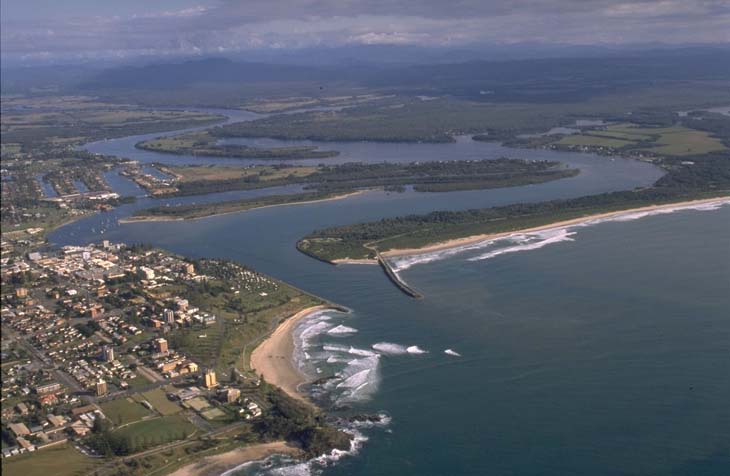
Aerial view of Hastings River
Seafood harvest area status
The NSW Food Authority website lists the current status of oyster/shellfish harvest areas.
Local government management
Local councils manage estuaries within their area unless the estuary is attached to a marine park. Port Macquarie Hastings Council manages this estuary. Resources can be found on its waterways and coastlines webpage.
Threatened species
The Hastings River estuary supports an endangered ecological community, lowland rainforest on floodplain, which provides habitat for the red‑legged pademelon.
Read more about the biodiversity in our estuaries.