The draft Native Vegetation Regulatory map displays the land categories outlined in the existing legislation that has been in place since 2017 (the Local Land Services Act and Local Land Services Regulation).
There are 6 different colours you might see on your map:
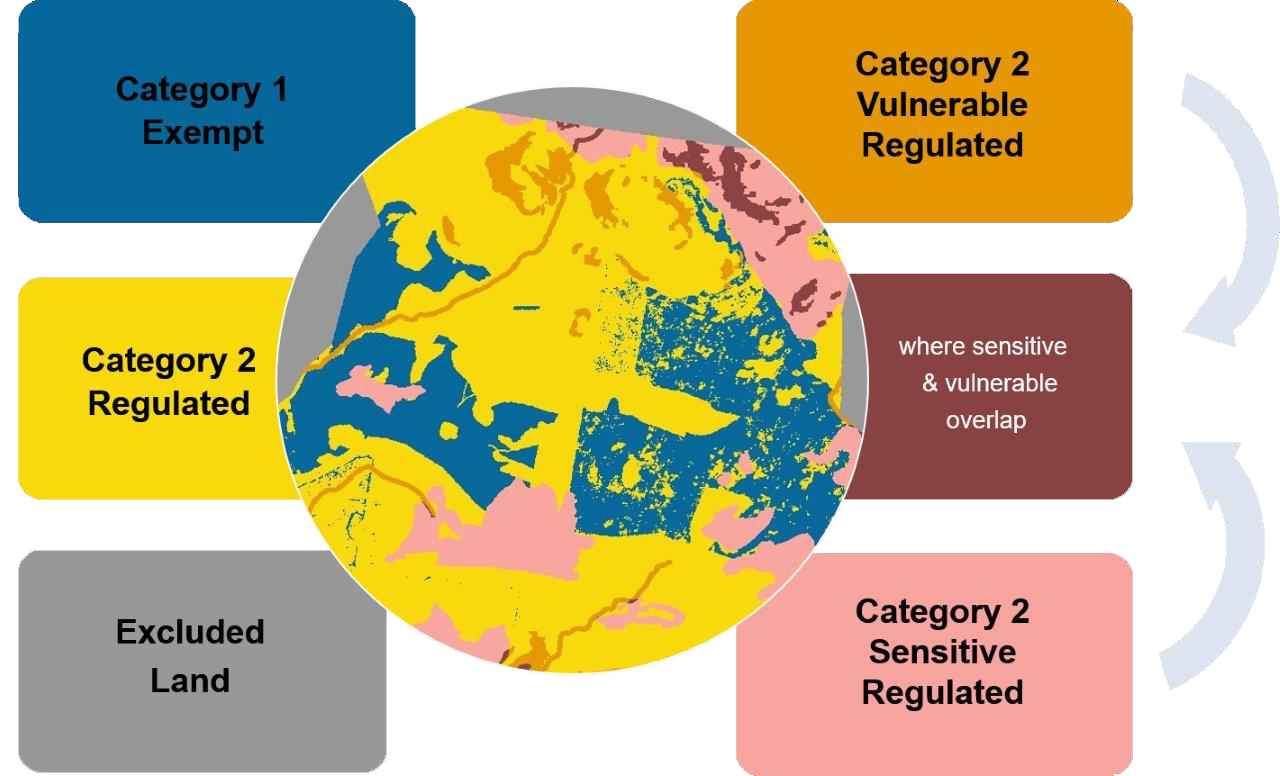
Native Vegetation Regulatory map categories
The 2 main land categories are shaded blue and yellow.
Category 1 exempt land (blue) is land where native vegetation can be cleared without approval from Local Land Services.
Category 2 land is divided into:
- category 2 regulated land (yellow) is category 2 land that is not Vulnerable or Sensitive regulated land. You may need authorisation from Local Land Services to clear native vegetation in this category. There are a range of allowable activities which can be carried out without needing authorisation.
- category 2–vulnerable regulated land (orange) is land where clearing of native vegetation may be limited under the Land Management (Native Vegetation) Code 2018, and a limited range of allowable activities are permitted.
- category 2–sensitive regulated land (pink) is land where clearing is not permitted under the Land Management Code (Native Vegetation) Code 2018, and a limited range of allowable activities is permitted.
Excluded land (grey) is land where the Land Management (Native Vegetation) Code 2018 and allowable activities do not apply.
Each land category is determined by various criteria as outlined in the Local Land Services Act 2013.
For more information on the categories and colours, go to the Native Vegetation Regulatory map guide.
What do the categories mean?
Criteria that apply to each land category
Each land category is determined by various criteria as outlined in the Local Land Services Act and Regulation.
| Land categories | Criteria |
|---|---|
| Exempt land (Category 1) |
|
| Regulated land (Category 2) (not including vulnerable or sensitive land) |
|
| Vulnerable regulated land (subcategory of Category 2) |
|
| Sensitive regulated land (subcategory of Category 2) |
|
| The Monaro Werriwa Critically Endangered Ecological Communities Advisory Layer | In some parts of New South Wales, a purple crosshatch is displayed on the Native Vegetation Regulatory map. This advisory/provisional layer indicates where certain critically endangered ecological communities are likely to occur. This is an advisory map layer only and not a Native Vegetation Regulatory map category. The function of the Advisory Layer is to alert landholders to the potential for critically endangered ecological communities to occur. Clearing of critically endangered ecological communities is generally not permitted. Local Land Services officers can assist landholders to undertake on-farm assessments and also provide further advice, including information on potential incentive programs. More information about the Monaro Werriwa critically endangered ecological communities can be found on our Threatened ecological communities webpage and the BioNet threatened biodiversity profiles webpage. |
Contact Local Land Services for further advice or approvals
Once you have viewed your map, if you require more information about the allowable activities that might be available to you or for approval to clear native vegetation on regulated land, please visit the Local Land Services website or call 1300 795 299.