The Murray and Lower Darling Baaka valleys cover 98,300 square kilometres and include the world’s largest stand of river red gum and Australia’s longest river, the Murray. Ramsar-listed sites include the Millewa, Werai and Koondrook–Perricoota forests, part of Chowilla Floodplain and the River Murray Channel. The catchment wetlands and rivers support important Aboriginal cultural heritage values.
The focus of Department of Planning Industry and Environment (the department) water managers in 2020–21 was to build on gains of previous years through the careful management of water for the environment.
The resource availability scenario was expected to be dry to very dry, as identified in the Murray and Lower Darling catchments: Annual environmental watering priorities 2020–21.
Inflows from the northern basin into the Menindee Lakes system resulted in flows over Weir 32 recommencing in March 2020, which connected Menindee Lakes and the Murray River for the first time in more than 12 months. Over the 2020–21 spring and summer, the Department oversaw the management of an environmental flow into the Lower Baaka River (Lower Darling Baaka River) to aid the recovery of native fish populations.
Key outcomes
In the Murray valley, managed watering events benefitted native fish, habitat condition and system productivity. For example:
- The department partnered with Murray Irrigation, private landholders and the Commonwealth Environmental Water Holder to deliver water into the Tuppal, Thule, Jimaringle-Cockran, Buccaneit, Yarrein and Murrain-Yarrein creeks to improve and support water quality, in-stream vegetation, waterbirds and native fish.
- Environmental water was delivered into the Gulpa Creek and Gulpa Creek Wetlands to provide breeding habitats for Murray cod and the nationally threatened Australasian bittern. Monitoring suggests that the Barmah–Millewa Forest Wetlands, which includes the Gulpa Creek Wetlands, provide nesting and foraging habitats for up to 20% of Australia’s Australasian bittern population.
- Water was delivered into several wetlands on private properties in the central and lower Murray to support recovery efforts for the nationally endangered southern bell frog, one of the NSW Government’s Saving our Species projects.
- Flows were delivered into the Lower Baaka from Menindee Lakes to provide longitudinal connectivity with the Murray River. This supported native fish recovery through spawning and recruitment and in-stream productivity benefits that means more food for fish.
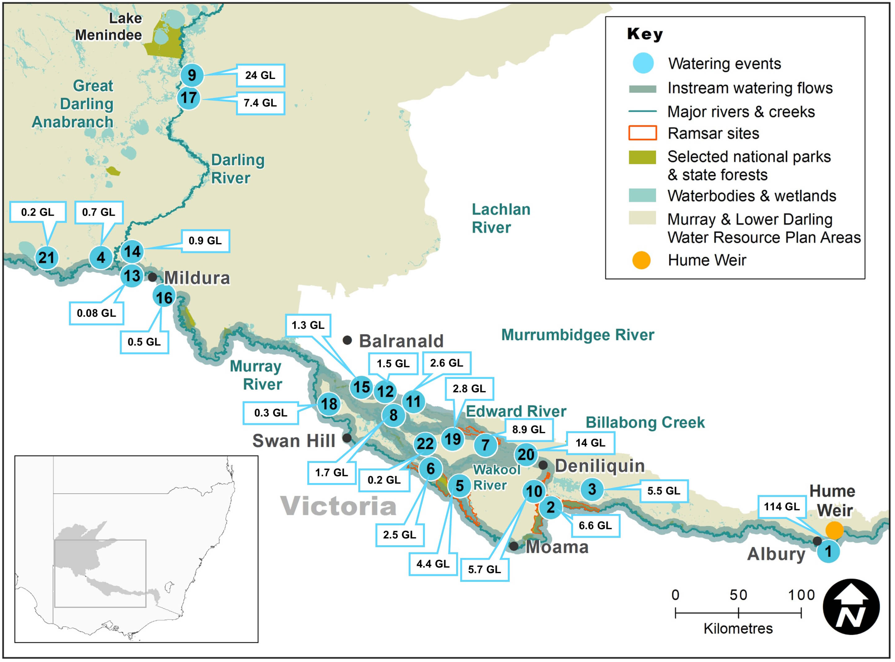
Murray and Lower Darling Baaka catchments area map
Watering aims
The annual objectives for the use of water for the environment are driven by the ecological objectives and targets outlined in the Murray–Lower Darling Baaka Long-Term Water Plan.
Water managers represented the NSW Government on the Southern Connected Basin Environmental Water Committee to deliver water strategically throughout the river system and provide for the year-round needs of native plants and animals. With advice from the Murray–Lower Darling Baaka Environmental Water Advisory Group, the department also delivered NSW Adaptive Environmental Water and the Murray Additional Allowance to several sites across the NSW Murray River catchment.
These watering events aimed to:
- connect the floodplain wetlands with the river, providing opportunities for native fish to feed, breed and move
- release essential nutrients from the floodplain floor to boost the aquatic food web
- encourage the ongoing recovery of wetland plants to provide habitat, feeding and breeding opportunities for wetland-dependent animals
- provide foraging opportunities for waterbirds
- replenish wetland refuges in anticipation of dry times in the future.
The watering aims identified in the Murray and Lower Darling catchments: Annual environmental watering priorities 2020–21 were largely implemented as proposed under the very dry to dry conditions.
Water delivery
This bar chart and table provide a summary of 237,497 megalitres of water for the environment delivered in the Murray–Lower Darling catchment during the 2020–21 watering year. Volumes are indicative only. Watering event numbers in the bar chart and table relate to location numbers marked on the map.
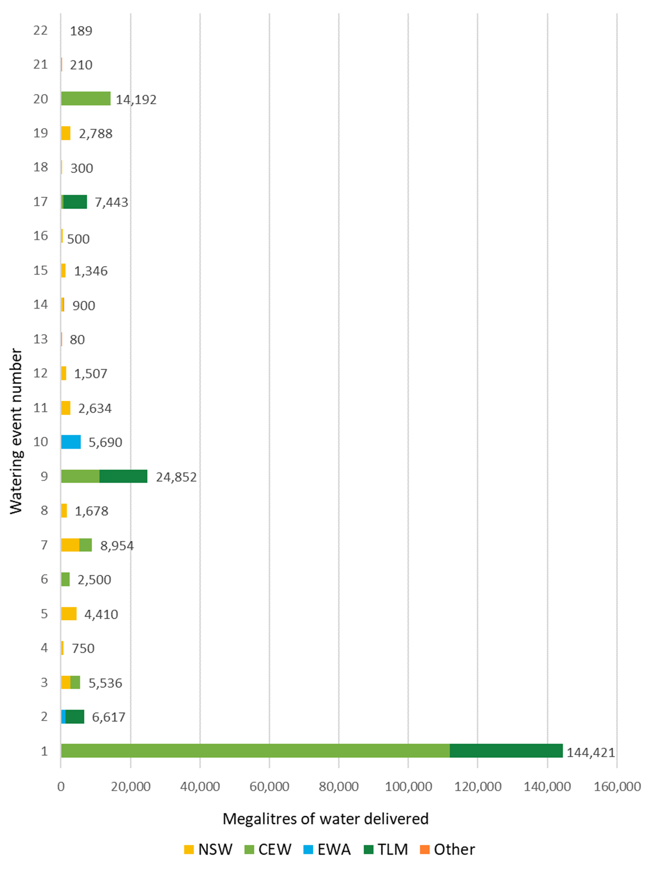
Bar chart showing water delivery to the Murray-Darling catchment in the 2020–21 water year.
Notes: NSW = NSW licensed environmental water; CEW = Commonwealth licensed environmental water; EWA = Environmental water allowance accrued under the Water Sharing Plan for the NSW Murray and Lower Darling Regulated Rivers Water Sources 2016; TLM = The Living Murray; RMIF = River Murray Increased Flows; Other = Murray–Darling Wetland Working Group
| Watering event number | Location | Outcomes | Start date | Finish date |
|---|---|---|---|---|
| 1 | River Murray multi-site | Native fish Waterbirds Vegetation Connectivity | 11 Sep 2020 28 May 2021 | 18 Dec 2020 17Jun 2021 |
| 2 | Millewa Forest | Native fish Waterbirds Vegetation Connectivity | 14 Aug 2020 | 12 Oct 2020 |
| 3 | Tuppal Creek | Native fish Vegetation Connectivity | 02 Sep 2020 | 01 Apr 2021 |
| 4 | Lower Murray Baaka wetlands | Waterbirds Vegetation | 03 Sep 2020 | 13 Sep 2020 |
| 5 | Thule Creek | Native fish Waterbirds Vegetation | 06 Sep 2020 | 03 Apr 2021 |
| 6 | The Pollack | Native fish Waterbirds Vegetation | 07 Sep 2020 | 01 Mar 2021 |
| 7 | Cockrans-Jimaringle creeks | Native fish Waterbirds Vegetation | 07 Sep 2020 | 24 May 2021 |
| 8 | Buccaneit–Cinninyeuk | Native fish Vegetation | 14 Sep 2020 | 05 Apr 2021 |
| 9 | Lower Darling Baaka spring–summer flows | Native fish | 15 Sep 2020 | 16 Jan 2021 |
| 10 | Gulpa Creek wetlands | Native fish Waterbirds Vegetation | 01 Oct 2020 | 31 Jan 2021 |
| 11 | Murrain–Yarrein creeks | Native fish Vegetation | 20 Oct 2020 | 03 Nov 2020 |
| 12 | Lake Agnes | Waterbirds Vegetation | 17 Mar 2021 | 03 May 2021 |
| 13 | Fletchers Creek | Waterbirds Vegetation | 01 Apr 2021 | 08 Apr 2021 |
| 14 | Grand Junction | Waterbirds Vegetation | 10 Apr 2021 | 27 May 2021 |
| 15 | Yarrein Creek | Native fish Vegetation | 14 Apr 2021 | 12 May 2021 |
| 16 | Bottle Bend floodplain | Waterbirds Vegetation | 10 Jul 2021 | 15 Jul 2021 |
| 17 | Lower Darling Baaka autumn–winter flows | Native fish | 02 May 2021 | 30 Jun 2021 |
| 18 | Bingerra Creek top up | Waterbirds Vegetation | 01 May 2021 | 09 May 2021 |
| 19 | Mid-Murray private wetlands | Waterbirds Vegetation | 26 May 2021 | 26 May 2021 |
| 20 | Edward/Kolety–Wakool River system | Native fish | 26 May 2021 | 26 May 2021 |
| 21 | Wingillie wetlands | Native fish Vegetation | 07 Apr 2021 | 06 May 2021 |
| 22 | Whymoul Creek | Native fish | 22 Jun 2021 | 22 Jun 2021 |
Outcomes
In 2020–21 water managers with the Department of Planning Industry and Environment – Environment, Energy and Science (DPIE – EES) worked collaboratively with the local community, state and commonwealth agencies, non-government organisations, First Nations groups, local irrigation corporations and private landholders to deliver positive ecological outcomes using water for the environment.
We worked with the Commonwealth Environmental Water Holder (CEWH) and partner agencies to manage a delivery of water along the Murray River from Hume Dam to the Lower Lakes in South Australia. We also partnered with the CEWH to achieve a range of environmental outcomes in the Edward–Wakool river system.
NSW and Commonwealth environmental water was delivered into private wetlands and ephemeral creeks in the mid-Murray, in collaboration with landholders and Murray Irrigation Limited to provide essential breeding habitats for the nationally threatened southern bell frog.
Planned environmental water (water for the environment allocated through the water sharing plan) was delivered into the Gulpa Creek to provide breeding habitats for the threatened Australasian bittern, Murray cod and trout cod. Monitoring funded by the Murray Darling Basin Authority through The Living Murray program reported large numbers of male Australasian bitterns calling across the Gulpa Creek Wetlands. Fish surveys by the Arthur Rylah Institute reported increased numbers of juvenile Murray cod and trout cod in the Gulpa Creek following the event.
We also partnered with the Commonwealth Environmental Water Holder (CEWH) and Southern Connected Basin Environmental Watering Committee to provide environmental flows for the Lower Baaka. Monitoring for the event was a collaboration between various agencies including DPIE – EES, Department of Primary Industries – Fisheries, NSW National Parks and Wildlife Service and the Arthur Rylah Institute (Victoria), which was funded by the CEWH. Outcomes included:
- longitudinal connection between the Menindee Lakes system and the Murray River
- increased access to habitat and food for native fish
- encouraged breeding, especially Murray cod, and movement of native fish including juvenile golden perch from Menindee Lakes into the Lower Baaka
- improved water quality.
Case study: Flows for fish and Australasian bitterns
Water for the environment was delivered into Gulpa Creek and the Barmah–Millewa Forest icon site from early September 2020 to January 2021 to provide breeding conditions for the nationally threatened Australasian bittern, Murray cod and trout cod.
Australasian bitterns and Murray cod are culturally significant to local First Nations groups and both animals feature in their dreaming stories. Kevin Atkinson, chair of the Cummeragunja Local Aboriginal Land Council board and proud Moiradu Bangerang man, said the Australasian bittern is synonymous with the bunyip dreaming story due to their strange booming call, and Murray cod and trout cod were an important part of Aboriginal peoples diets when native fish were plentiful.
'We are very sad to see the demise of these animals but heartened to know that environmental water is being used to support their recovery,' said Atkinson.
Flows into the Gulpa Creek were designed to ensure the timing, duration and magnitude were sufficient for Australasian bitterns and native fish to breed successfully.
First Nations groups and the Edward–Wakool Angling Association attended an online workshop to help plan the event.
The water used for the event included 5690 megalitres of NSW Murray Additional Allowance. The Gulpa Creek event was also incorporated into the Murray River multi-site (Hume to South Australia) event.
Monitoring detected 44 male Australasian bitterns (and 29 little bitterns) calling at wetland sites within Barmah–Millewa Forest. Seventeen of the 44 bitterns were located in the Gulpa Creek wetlands.
Native fish population surveys were conducted by Arthur Rylah Institute in the Barmah–Millewa Forest. There was a strong indication that Murray cod and trout cod are beginning to rebuild populations from natural recruitment in the local region, particularly in Gulpa Creek. More Murray cod were collected in 2021 than in previous years. This increase was most evident in Gulpa Creek, with a relatively high abundance of juvenile native fish.
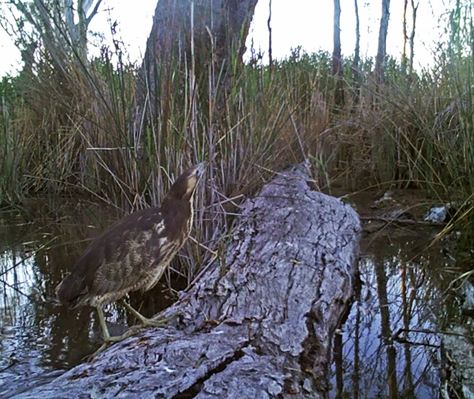
An Australasian bittern (Botaurus poiciloptilus)