Cockrone Lagoon is situated on the Central Coast of New South Wales between Copacabana and MacMasters Beach. It is classed as a back-dune lagoon with an intermittently closed entrance. Artificial entrance openings are carried when water height reaches a certain trigger level. This trigger level is higher than nearby lagoons because less urban development has encroached on the lagoon foreshore.
Water quality
As part of our water quality monitoring program we assess the water quality and ecosystem health of an estuary using a range of relevant indicators.
We sample 2 sites on a monthly basis over summer in Cockrone Lagoon as part of a collaborative program with Central Coast Council.
The most recent sampling was completed over the 2020–21 summer. The results of the monitoring program, including a detailed water quality report card for Cockrone Lagoon, are available on the Central Coast Council website.
Go to estuary report cards to find out what each grade means, read our sampling, data analysis and reporting protocols, and find out how we calculate these grades.
As part of our Beachwatch program we assess swimming suitability at one swimming site in Cockrone Lagoon using microbial indicators. Central Coast Council collect samples at each site weekly between October and April, and monthly from May to September, to calculate the suitability grade. Sampling is ongoing. The grade reflects the most recent 100 water quality results to April 2022. Find out more about how we monitor beach water quality.
| Local government area | Swim site name | Grade |
|---|---|---|
| Central Coast | Cockrone Lagoon | Poor |
Estuarine, lake and lagoon water can sometimes be unsuitable for swimming, especially after rainfall, when stormwater and wastewater can overflow into swimming areas. Learn more about what the grades mean and how we grade swimming sites on the Beachwatch How we report webpage.
Water sampling and laboratory analysis were funded by Central Coast Council.
Physical characteristics
| Estuary type | Back-dune lagoon |
|---|---|
| Latitude | –33.49 (ºS) |
| Longitude | 151.43 (ºE) |
| Catchment area | 6.9 km2 |
| Estuary area | 0.3 km2 |
| Estuary volume | 187.4 ML |
| Average depth | 0.6 m |
Notes: km2 = square kilometres; m = metres; ML = megalitres.
Water depth and survey data
Bathymetric and coastal topography data for this estuary are available in our data portal.
Land use
Cockrone Lake drains a predominantly forested catchment, part of which is in a conservation area. Urban and rural-residential development has led to moderate disturbance within the catchment, representing around a third of land use.
National and marine parks
- Part of Bouddi National Park falls within this catchment.
- This estuary does not flow into a marine park.
Community involvement
- The Central Coast Council’s Landcare Program supports local volunteer groups to conserve, protect and remediate different environments in the Cockrone Lake area, such as Copacabana Dunecare and Allagai Bushcare at MacMasters Beach.
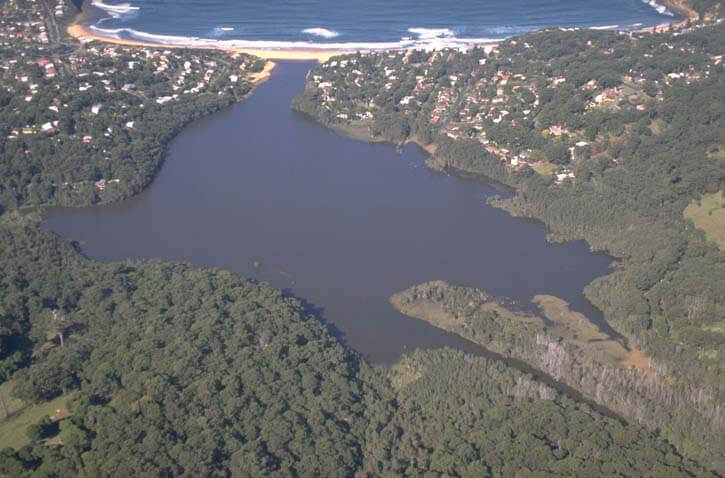
Aerial view of Cochrane Lagoon
Local government management
Local councils manage estuaries within their area unless the estuary is attached to a marine park. Central Coast Council manages this estuary.
Information about this estuary can be found on the council’s Coastal lagoons webpage.
Threatened species
Kincumber scribbly gum forest, a critically endangered ecological community, is found within this catchment.
Read more about the biodiversity in our estuaries.