Duchess Gully estuary is situated on the mid-north coast of New South Wales, in Bonny Hills.
Duchess Gully is a small coastal creek with an intermittently open entrance. The estuary is tucked in behind beach dunes, draining an area subject to new urban development.
Water quality report card
As part of our water quality monitoring program we assess the water quality and ecosystem health of an estuary using a range of relevant indicators. We sample a subset of the estuaries located between the Queensland border and Taree every 3 years. The most recent sampling in Duchess Gully was completed over the 2018–19 summer, when 2 sites were sampled on a monthly basis.
This report card represents 2 water quality indicators that we routinely measure: the amount of algae present and water clarity. Low levels of these 2 indicators equate with good water quality.
Algae
Water clarity
Overall grade
The report card shows the condition of the estuary was good with:
- algae abundance graded fair (C)
- water clarity graded good (B)
- overall estuary health graded good (B).
Grades for algae, water clarity and overall are represented as:
- A – excellent
- B – good
- C – fair
- D – poor
- E – very poor.
Go to estuary report cards to find out what each grade means, read our sampling, data analysis and reporting protocols, and find out how we calculate these grades.
We have monitored water quality in the Duchess Gully since 2012. This table shows the water quality grades for this estuary over that time.
| Year | Algae | Water clarity | Overall grade |
|---|---|---|---|
| 2012–13 | C | B | C |
| 2015–16 | C | D | C |
Physical characteristics
| Estuary type | Creek |
|---|---|
| Latitude | –31.59 (ºS) |
| Longitude | 152.84 (ºE) |
| Catchment area | 10.6 km2 |
| Estuary area | 0.02 km2 |
| Estuary volume | 5.4 ML |
| Average depth | 0.2 m |
Notes: km2 = square kilometres; m = metres; ML = megalitres.
Water depth and survey data
Bathymetric and coastal topography data for this estuary are available in our data portal.
Land use
The catchment of Duchess Gully is highly disturbed. The lower estuary flows through an area of coastal bushland, but over half of land within the catchment is used for urban areas and associated cleared grazing land. A wastewater treatment plant is located along the creek.
National and marine parks
- Queens Lake State Conservation Area is the largest conservation area in this catchment.
- This estuary does not flow into a marine park.
Community involvement
- Bonny Hills Landcare forms part of the Hastings Landcare umbrella group. Persistent work over many years has significantly reduced weeds and allowed local native plant species to regenerate on the headland and dune areas around Duchess Gully.
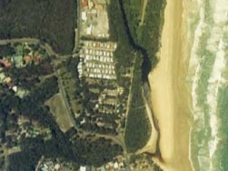
Aerial view of Duchess Gully estuary
Local government management
Local councils manage estuaries within their area unless the estuary is attached to a marine park. Duchess Gully estuary is managed by Port Macquarie Hastings Council.
Threatened species
Estuaries provide important protected environments where native plants like seagrass and mangroves grow and create habitat for fish and other animals.
Read more about the biodiversity in our estuaries.