The Brunswick River is a wave-dominated barrier estuary with an open entrance on the north coast of New South Wales. Training walls extend out to sea to ensure the entrance to the estuary remains open.
The Brunswick River estuary is formed by 3 main arms:
- Marshalls Creek (North Arm)
- Brunswick River (Main Arm)
- Simpsons Creek (South Arm).
Other tributaries of Brunswick River include Mullumbimby Creek and Kings Creek.
Brunswick River estuary supports extensive wetland areas, including the nationally significant Billinudgel Nature Reserve, which is listed in the Directory of Important Wetlands in Australia.
The estuary is a central feature of the town of Brunswick Heads, which is a popular destination for recreational beach activities and river fishing. The estuary supports a range of commercially important fish and provides significant shorebird habitat. Over 20 square kilometres of wetlands within the Brunswick River catchment are protected under State Environmental Planning Policy (Resilience and Hazards) 2021.
Water quality report card
As part of our water quality monitoring program we assess the water quality and ecosystem health of an estuary using a range of relevant indicators. We sample a subset of the estuaries located between the Queensland border and Taree every 3 years. The most recent sampling in the Brunswick River was completed over the 2021–22 summer, when 2 sites were sampled on a monthly basis.
This report card represents 2 water quality indicators that we routinely measure: the amount of algae present and water clarity. Low levels of these 2 indicators equate with good water quality.
Algae
Water clarity
Overall grade
The report card shows the condition of the estuary was fair with:
- algae abundance graded fair (C)
- water clarity graded poor (D)
- overall estuary health graded fair (C).
Grades for algae, water clarity and overall are represented as:
- A – excellent
- B – good
- C – fair
- D – poor
- E – very poor.
Go to estuary report cards to find out what each grade means, read our sampling, data analysis and reporting protocols, and find out how we calculate these grades.
We have monitored water quality in the Brunswick River since 2007. This table shows the water quality grades for this estuary over that time.
| Year | Algae | Water clarity | Overall grade |
|---|---|---|---|
| 2007–08 | D | C | C |
| 2009–10 | C | B | C |
| 2012–13 | C | B | C |
| 2015–16 | D | B | C |
| 2018–19 | E | C | D |
Physical characteristics
| Estuary type | Barrier river |
|---|---|
| Latitude | –28.54 (ºS) |
| Longitude | 153.56 (ºE) |
| Catchment area | 226.3 km2 |
| Estuary area | 3.6 km2 |
| Estuary volume | 4267.9 ML |
| Average depth | 1.3 m |
Tidal exchange volume
Tidal exchange volume or tidal prism data is available for this estuary. This tidal prism was measured in 2005.
| Tide state | Flow (ML) | Local tidal range (m) | Sydney Harbour tidal range (m) |
|---|---|---|---|
| Ebb flow | 2,080 | 1.34 | 1.33 |
| Flood flow | 2,000 | 1.45 | 1.38 |
Notes: km2 = square kilometres; m = metres; m3 = cubic metres; ML = megalitres.
Water depth and survey data
Bathymetric and coastal topography data for this estuary are available in our data portal.
Land use
The main land uses in the Brunswick River catchment are associated with farming and include cattle grazing, horticulture, sugar cane and tea plantations. Around one-quarter of the catchment is forested and is managed in conservation areas or is under private ownership. Urban areas occupy about 20% of the catchment and include Mullumbimby, Brunswick Heads, Ocean Shores (including New Brighton the South Golden Beach) and Billinudgel. Tourism activities centre around Brunswick Heads.
Water use
Find out about water use in the Brunswick River and its catchment, including information about major water users, real-time flow data, and environmental and water sharing plans.
Web cam
The Brunswick Heads bar crossing web camera provides real-time video of conditions within the river entrance immediately offshore to help with bar crossings and boat safety.
National and marine parks
- Billinudgel Nature Reserve is the largest conservation area in the Brunswick River catchment.
- This catchment also includes the Byron Coast Group of Reserves: the Tyagarah, Brunswick Head and Broken Head Nature Reserves. These reserves are regionally significant wildlife corridors for north–south migration along the north coast.
- The tidal waters of the Brunswick River and its tributaries are managed as part of the Cape Byron Marine Park.
Citizen science projects
- Byron Bird Buddies is a volunteer community group involved in bird monitoring, conservation, habitat protection and education in the Northern Rivers region.
Community involvement
- Brunswick Valley Landcare is a not-for-profit group that helps Landcare groups and landholders in the Brunswick River catchment to conduct conservation and restoration projects – from forest to foreshore.
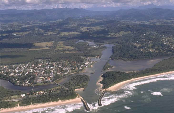
Aerial view of Brunswick River estuary.
Local government management
Local councils manage estuaries within their area unless the estuary is attached to a marine park. Byron Shire Council and Cape Byron Marine Park manage this estuary.
Threatened species
The Brunswick River catchment area provides habitat and supports a number of threatened species, such as the Brunswick–Tweed koala population and the beach stone-curlew. Pied oystercatchers nest within the estuary in the Brunswick Heads Nature Reserve.
Read more about the biodiversity in our estuaries.