Bellinger River is situated on the mid-north coast of New South Wales and meets the sea near Urunga.
Bellinger River estuary is a barrier river estuary. The lower estuary is formed where the Kalang River merges with the Bellinger River, creating a large and dynamic system. There is a southern training wall at the entrance that maintains a permanent channel to the sea. Other training walls have been constructed further upstream where the 2 rivers converge.
Water quality report card
As part of our water quality monitoring program we assess the water quality and ecosystem health of an estuary using a range of relevant indicators. We sample a subset of the estuaries located between the Queensland border and Taree every 3 years. The most recent sampling in the Bellinger River was completed over the 2021–22 summer, when 2 sites were sampled on a monthly basis.
This report card represents 2 water quality indicators that we routinely measure: the amount of algae present and water clarity. Low levels of these 2 indicators equate with good water quality.
Algae
Water clarity
Overall grade
The report card shows the condition of the estuary was excellent with:
- algae abundance graded excellent (A)
- water clarity graded good (B)
- overall estuary health graded excellent (A).
Grades for algae, water clarity and overall are represented as:
- A – excellent
- B – good
- C – fair
- D – poor
- E – very poor.
Go to estuary report cards to find out what each grade means, read our sampling, data analysis and reporting protocols, and find out how we calculate these grades.
We have monitored water quality in the Bellinger River estuary since 2009. This table shows the water quality grades for this estuary over that time.
| Year | Algae | Water clarity | Overall grade |
|---|---|---|---|
| 2009–10 | B | B | B |
| 2018–19 | C | A | B |
Physical characteristics
| Estuary type | Barrier river |
|---|---|
| Latitude | –30.5 (ºS) |
| Longitude | 153.03 (ºE) |
| Catchment area | 1100.3 km2 |
| Estuary area | 8.2 km2 |
| Estuary volume | 14,441.6 ML |
| Average depth | 1.8 m |
Tidal exchange volume
Tidal exchange volume or tidal prism data is available for this estuary. This tidal prism was measured in 2001.
| Tide state | Flow (ML) | Local tidal range (m) | Sydney Harbour tidal range (m) |
|---|---|---|---|
| Ebb flow | 2,450 | 1.16 | 1.53 |
| Flood flow | 2,550 | 1.26 | 1.58 |
Notes: km2 = square kilometres; m = metres; m3 = cubic metres; ML = megalitres.
Water depth and survey data
Bathymetric and coastal topography data for this estuary are available in our data portal.
Land use
The catchment of the Bellinger River is slightly disturbed. Around 85% of the catchment remains forested, a lot of which is in the undulating areas of the upper catchment. Around 15% of land use has been changed, predominantly for cattle grazing, and these areas are concentrated along the floodplains of the river and its tributaries. Bellingen and Urunga are the major towns within the catchment; however, they make up a small fraction of the land use within this large catchment.
Water use
DPE – Water provides a description of water in the Bellinger River and catchment, including information about its uses, values, and environmental and water sharing plans.
National and marine parks
- New England National Park is the largest conservation area within the Bellinger River catchment.
- This estuary does not flow into a marine park.
Citizen science projects
- Bellingen Riverwatch is a citizen science program that involves monitoring water quality of the Bellinger River to support the existence of the snapping turtle (Myuchelys georgesi) in the wild.
Community involvement
- Bellinger Landcare Inc is a community-based organisation that provides workshops and volunteer environmental work opportunities throughout the Bellingen Shire.
- Jaliigirr Biodiversity Alliance is a voluntary partnership of 20 natural resource management stakeholders who work to maintain the biodiversity of the region by protecting and enhancing landscape connections.
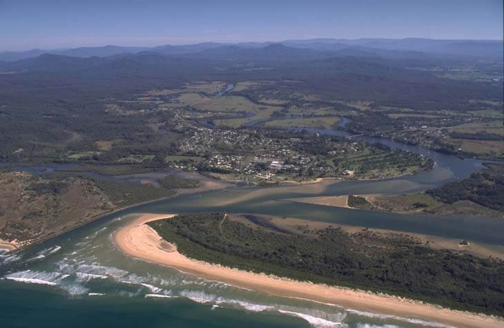
Aerial review of Bellinger River estuary.
Seafood harvest area status
The NSW Food Authority website lists the current status of oyster/shellfish harvest areas.
Local government management
Local councils manage estuaries within their area unless the estuary is attached to a marine park.
Bellinger River is managed by Bellingen Shire Council. Information about the Bellinger River estuary can be found on the council’s Coast and waterways webpage.
Threatened species
Many threatened species live in the Bellinger River catchment including the Bellinger River snapping turtle, the curlew sandpiper and the beach stone-curlew.
Read more about the biodiversity in our estuaries.