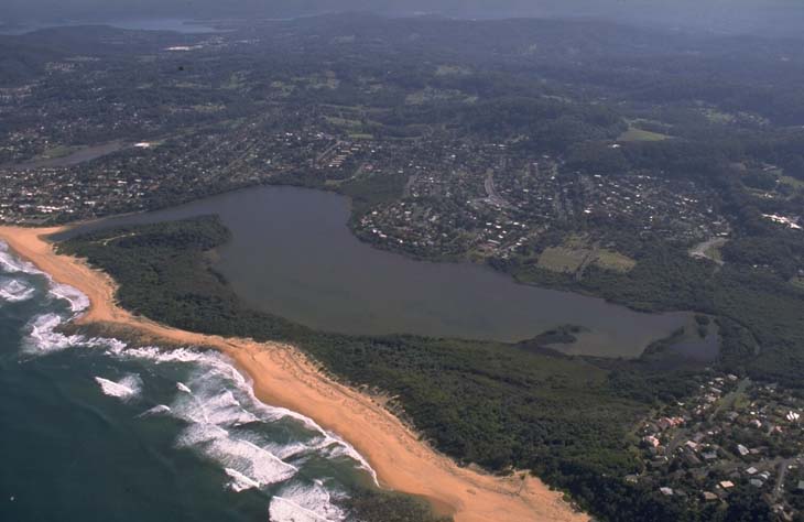
Wamberal Lagoon is situated on the central coast of New South Wales. It is classed as a back-dune lagoon with an intermittently closed entrance to the sea.
The entrance to the estuary is managed and artificial openings occur when water levels reach a specific trigger level during storms. Extensive vegetation occurs around the edges of the estuary, which provides important habitat and acts as a buffer for stormwater runoff.
Water quality report card
As part of our water quality monitoring program we assess the water quality and ecosystem health of an estuary using a range of relevant indicators. We sample 2 sites on a monthly basis over summer in Wamberal Lagoon as part of a collaborative program with Central Coast Council. The most recent sampling was completed over the 2020–21 summer.
The results of the monitoring program, including a detailed water quality report card for Wamberal Lagoon, are available on the Central Coast Council website.
This report card represents 2 water quality indicators that we routinely measure: the amount of algae present and water clarity. Low levels of these 2 indicators equate with good water quality.
Physical characteristics
| Estuary type | Back-dune lagoon |
|---|---|
| Latitude (ºS) | –33.43 |
| Longitude (ºE) | 151.45 |
| Catchment area (km2) | 5.8 |
| Estuary area (km2) | 0.5 |
| Estuary volume (ML) | 880.2 |
| Average depth (m) | 1.7 |
Notes: km2 = square kilometres; m = metres; ML = megalitres.
Water depth and survey data
Bathymetric and coastal topography data for this estuary are available in our data portal.
Land use
Wamberal Lagoon drains a highly disturbed catchment. The immediate area surrounding the estuary is protected within the Wamberal Lagoon Nature reserve, but about 90% of the catchment falls outside of this nature reserve. The main land use change has been urban development, which continues with an expanding local population. Small-scale intensive agriculture also occurs within the catchment.
National and marine parks
- Wamberal Lagoon Nature encompasses the lagoon and its foreshore.
- This estuary does not flow into a marine park.
Community involvement
- The Central Coast Council's Environmental groups webpage provides links and information about a range of volunteer groups working to care for the environment in the area, included the Wamberal Lagoon Bushcare Group.

Aerial view of Wamberal Lagoon estuary.
Local government management
Local councils manage estuaries within their area unless the estuary is attached to a marine park.
Central Coast Council manages this estuary. More information about Wamberal Lagoon can be found on the Council’s Coastal lagoons webpage.
Threatened species
Wamberal Lagoon supports habitat for many threatened species, including the endangered curlew sandpiper.
Read more about the biodiversity in our estuaries.