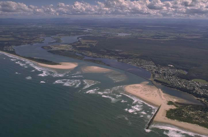
The Manning River estuary is situated on the mid-north coast of New South Wales. It is a large, 250-kilometre-long barrier river with a permanently open trained entrance at Harrington (pictured), and a second predominantly closed entrance where the south arm reaches the sea near Old Bar.
The Manning River drains the fifth biggest catchment on the New South Wales coast. It is one of Australia’s few large river systems that has not been dammed for water supply purposes. It dominates the Manning Valley, supporting commercial industry and providing enormous recreational and ecological value.
Water quality
As part of our water quality monitoring program we assess the water quality and ecosystem health of an estuary using a range of relevant indicators.
We sample 9 sites on a monthly basis over summer in the Manning River estuary as part of a collaborative program with MidCoast Council. The most recent sampling was completed over the 2023–24 summer. The results of the monitoring program, including a detailed water quality report card for the Manning River, are available on the MidCoast Council website.
Go to estuary report cards to find out what each grade means, read our sampling, data analysis and reporting protocols, and find out how we calculate these grades.
Physical characteristics
| Estuary type | Barrier river |
|---|---|
| Latitude (ºS) | –31.88 |
| Longitude (ºE) | 152.7 |
| Catchment area (km2) | 8124.5 |
| Estuary area (km2) | 34.7 |
| Estuary volume (ML) | 96,258.5 |
| Average depth (m) | 3 |
Tidal exchange volume
Tidal exchange volume or prism data is available for this estuary. This tidal prism was measured in 1998.
| Tide state | Flow (ML) | Local tidal range (m) | Sydney Harbour tidal range (m) |
|---|---|---|---|
| Ebb flow | 14,830 | 1.31 | 1.57 |
| Flood flow | 10,080 | 1.05 | 1.45 |
Notes: km2 = square kilometres; m = metres; m3 = cubic metres; ML = megalitres.
Water depth and survey data
Bathymetric and coastal topography data for this estuary are available in our data portal.
Land use
The catchment of the Manning River has seen significant land-use changes. Most of the mid and lower catchment have been cleared for beef and dairy production, and this accounts for around 40% of total land use.
Forest covers over half of the catchment, particularly in steeper areas of the upper catchment, but also interspersed with pastoral and rural-residential land in the lower catchment. The major towns in the Manning catchment are Taree and Wingham.
Water use
Find out about water use in the Manning River, including information about major water users, real-time flow data, and environmental and water sharing plans.
National and marine parks
- Barrington Tops National Park is the largest conservation area in this catchment.
- This estuary does not flow into a marine park.
Community involvement
- Taree Landcare provides volunteers the opportunity to get involved in bush regeneration in the Taree area.
- Manning Landcare is an umbrella landcare organisation that supports Landcare and environmental groups in the local area.
Seafood harvest area status
The NSW Food Authority website lists the current status of oyster/shellfish harvest areas.

Aerial view of the Manning River estuary
Local government management
Local councils manage estuaries within their area. Where an estuary is attached to a marine park, marine park management teams are responsible for ensuring compliance with marine park zoning.
MidCoast Council manage this estuary. More information about this estuary can be found on the council’s River, lake and estuary management webpage.
Threatened species
The endangered Manning River helmeted turtle is endemic to the middle and upper reaches of the Manning River catchment area.
Read more about the biodiversity in our estuaries.