Moruya River is a located in a large catchment area on the south coast of New South Wales. The estuary has 2 training walls that keep it permanently open to the sea. It is classed as a barrier river estuary.
Malabar Lagoon – also known as Malabar Creek – supports saltmarsh, seagrass meadows and mangroves, and is an important arm of the Moruya River estuary.
Quondolo Island, another feature of the Moruya River estuary, is protected as part of Eurobodalla National Park. The island supports a range of coastal vegetation including swamp oak and coastal banksia, which provide important shelter for shorebirds, and mudflats surrounding the island provide a food source for the birds and crustaceans.
Historically, Moruya River is known as the site which provided granite for piers and pylons of the Sydney Harbour Bridge.
Water quality report card
As part of our water quality monitoring program we assess the water quality and ecosystem health of an estuary using a range of relevant indicators. We sample a subset of the estuaries between Wollongong and the Victorian border every 3 years. The most recent sampling in Moruya River was completed over the 2020–21 summer, when 2 sites were sampled on a monthly basis.
This report card represents 2 water quality indicators that we routinely measure: the amount of algae present and water clarity. Low levels of these 2 indicators equate with good water quality.
Algae
Water clarity
Overall grade
The report card shows the condition of the estuary was excellent with:
- algae abundance graded excellent (A)
- water clarity graded excellent (A)
- overall estuary health graded excellent (A).
Grades for algae, water clarity and overall are represented as:
- A – excellent
- B – good
- C – fair
- D – poor
- E – very poor.
Go to estuary report cardsto find out what each grade means, read our sampling, data analysis and reporting protocols, and find out how we calculate these grades.
Eurobodalla Shire Council have a long-term water quality monitoring program in the Moruya River, based on the same sampling and reporting methods as our statewide program. The results of the monitoring program, including a detailed water quality report card, are available on the Eurobodalla Shire Council website.
We have monitored water quality in Moruya River since 2008. This table shows the water quality grades for this estuary over that time.
| Year | Algae | Water clarity | Overall grade |
|---|---|---|---|
| 2008–09 | B | A | A |
| 2017–18 | B | A | B |
Physical characteristics
| Estuary type | Barier river |
|---|---|
| Latitude (ºS) | –35.91 |
| Longitude (ºE) | 150.51 |
| Catchment area (km2) | 1423.7 |
| Estuary area (km2) | 6.1 |
| Estuary volume (ML) | 10,168 |
| Average depth (m) | 1.9 |
Tidal exchange volume
Tidal exchange volume or tidal prism data is available for this estuary. This tidal prism was measured in 2000.
| Tide state | Flow (ML) | Local tidal range (m) | Sydney Harbour tidal range (m) |
|---|---|---|---|
| Ebb flow | 4,880 | 1.21 | 1.47 |
| Flood flow | 480 | 1.22 | 1.41 |
Notes: km2 = square kilometres; m = metres; m3 = cubic metres; ML = megalitres.
Water depth and survey data
Bathymetric and coastal topography data for this estuary are available in our data portal.
Land use
The catchment of the Moruya River has relatively low disturbance, with 85% remaining forested, including Deua National Park. Grazing areas on the floodplain and at Araluen and Neringla make up 10% of the catchment and urban areas form 2% including Moruya.
Water use
Find out about water use in the Moruya River, including information about major water users, real-time flow data, and environmental and water sharing plans.
Moruya bar crossing webcam
The Moruya bar crossing web camera provides real-time video of conditions of the river entrance channel immediately offshore to help with bar crossings and boat safety.
National and marine parks
- The largest conservation area in the Moruya River catchment is Deua National Park.
- The Moruya River estuary flows into the Batemans Marine Park.
Citizen science projects
- iNaturalist’s Plants of Eurobodalla is a citizen science project that monitors plants found in the Eurobodalla region.
Community involvement
- Eurobodalla Landcare is a volunteer network of 24 Landcare groups on the New South Wales south coast.
- The Coastwatchers Association is a community environmental and conservation group based on the south coast.
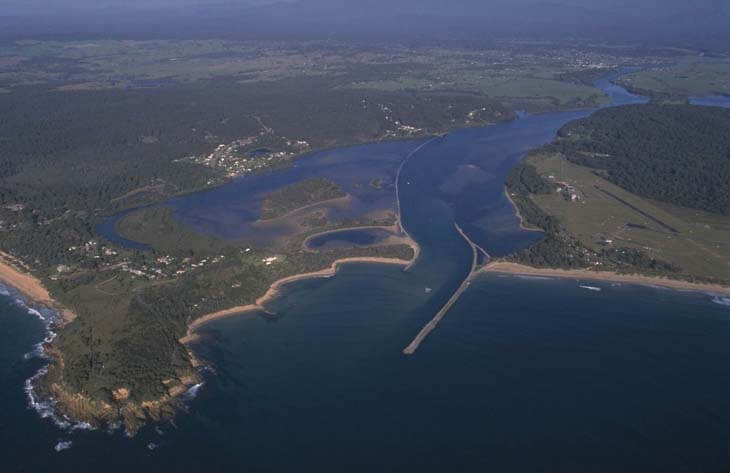
Aerial view of Moruya River estuary.
Local government management
Local councils manage estuaries within their area unless the estuary is attached to a marine park.
Eurobodalla Shire Council manages this estuary, which is located in Batemans Marine Park.
Threatened species
Moruya River and its surrounding waterways contain saltmarsh and seagrass meadows, which provide important habitat, shelter and breeding grounds.
Read more about plants found in our estuaries.