Overview
- In 2019, record high temperatures, severe multi-year rainfall deficiencies, very low humidity, and strong and gusty winds led to dangerous fire weather conditions throughout New South Wales (NSW) from July to December. These conditions combined with very high dryness in fuel loads to increase bushfire risk.
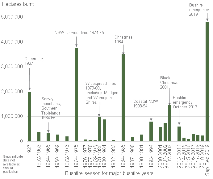
- NSW Rural Fire Service (RFS) records showed that the total area burned from September to December 2019 was around 4 million hectares, with lives lost and hundreds of homes destroyed. The extent of fires was unprecedented in NSW Government’s records.
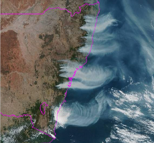
- Multiple large and dangerous bushfires across eastern NSW from September to December brought thick smoke, blanketing populated areas from the NSW Northern Tablelands to the Far South Coast regions. This resulted in reduced visibility and poor to hazardous air quality.
- The geographic extent, duration and levels of PM2.5 particles (particulate matter less than 2.5 micrometres in diameter) observed simultaneously across multiple regions, resulted in the longest severe air pollution event for northern, central and coastal areas of NSW since 1998.
- The NSW Government started bushfire related air quality monitoring in late July, when smoke from a major fire affected local communities near Port Macquarie (Mid-north Coast). During the bushfire emergency period (October to December), monitoring was extended to Lismore and Coffs Harbour (NSW Northern Rivers/Mid-north Coast regions) in November. Additional indicative monitoring of hourly particle levels started in Grafton (Northern Rivers), Coffs Harbour and Taree (Mid-north Coast) in November and in Batemans Bay and Ulladulla (South Coast) in December.
- Port Macquarie reported the highest PM2.5 daily average on record in NSW to the end of 2019 on 15 November 2019, with a daily average of 443 micrograms per cubic metre (µg/m3). On this day, Port Macquarie also recorded the highest carbon monoxide levels on record at a non-roadside site in NSW in the last 25 years.
- The new Goulburn monitoring station recorded hourly nitrogen dioxide levels over the national standard, reaching 16.1 pphm, the highest recorded value since 1994. This event was due to bushfire smoke.
Indicative monitoring recorded very high hourly PM2.5 readings due to their closeness to bushfires. For example, the highest hourly PM2.5 levels, recorded by an indicative monitor, were 1,675 µg/m3 at Ulladulla on 23 December and 2,500 µg/m3 at Batemans Bay on 31 December [note: these readings are not directly comparable to any particle related standards].
Extreme bushfire weather
The dangerous fire weather conditions of the first half of the 2019-2020 bushfire season were preceded by prolonged and intensifying drought across NSW from 2017 to 2019. The bushfire risk was exacerbated by warmer than average temperatures, severe rainfall deficiencies, very low humidity and gusty winds, combined with very high dryness in fuel loads (refer to Climate section; Bureau of Meteorology Special Climate Statement 71).
Locations in the north-east recorded Forest Fire Danger Index (FFDI) values in the catastrophic category on 6 September, which marked the onset of numerous large bushfires. This was the highest FFDI for the north-east since records began in 1950. The FFDI was in the very high category for 21 days during spring 2019. The previous highest count was 11 such days in spring 2002 and an average count of 2 days (Bureau of Meteorology Special Climate Statement 72). Catastrophic fire weather led the NSW Government to declare a 7-day “State of Emergency” on 11 November and 19 December 2019.
Bushfires
The NSW Government records showed that around 4 million hectares were burnt in late 2019, and the extent of the bushfires was unprecedented in the NSW Government’s historical records.
Sources:
NSW Parliamentary Research Briefing No.05/2002 for 1926 to 2002.
Year Book Australia, 2004, Australian Bureau of Statistics, for 1 July 2002 to 28 February 2003, accessed 8 January 2020.
NSW Rural Fire Service ICON database for 2013 to 2019, accessed 7 January 2020.
Summary of major fires in New South Wales, 1 September to 31 December 2019
| Region | Major fires >100,000 ha |
|---|---|
North (Northern Rivers, North Coast, Northern Tablelands, Northern Slopes and Plains) | Carrai Creek (238, 602 ha) Liberation Trail (183,653 ha) Carrai East (149,534 ha) Washpool State Forest (133,318 ha) Myall Creek Road (121,324 ha) Kaloe Mountain (120,866 ha) Bees Nest (113,706 ha) |
East (Metropolitan, Blue Mountains, Lower North Coast, Hunter, Central Coast, South Coast) | Gospers Mountain (Wollemi National Park, 511,661 ha) Kerry Ridge (Wollemi National Park, 323,901 ha) Green Wattle Creek (south-west of Warragamba Dam, 274,068 ha) Little L Complex (Yengo National Park, 166,590 ha) Rumba Complex (Manning-Hastings, 151,654 ha) |
South and West (ACT, Southern Ranges, Western Rivers, Far West) | No fires greater than 100,000 ha to end of 2019 |
Source: Rural Fire Service, ICON database, accessed 7 January 2020
Bushfire emergency and air quality monitoring
Note regarding availability of data
Data availability in December was reduced at NSW air quality monitoring stations near bushfire grounds. The duration, extent and magnitude of the fires and smoke affected power supplies, filter loads on monitoring instruments and site access, disrupting automated data collection. Insufficient PM2.5 hourly data were available to calculate the daily averages between 1 and 4 days at Oakdale, Randwick, Bringelly and Bargo in Sydney, Orange and Bathurst in the Central Tablelands, Narrabri in the North-west Slopes and Armidale in the Northern Tablelands.
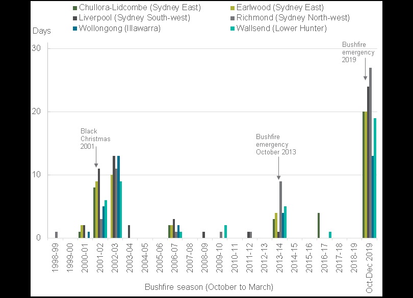
The NSW air quality monitoring network recorded more days above the PM2.5 national standard and with higher maximum levels from October to December 2019, than in any previous bushfire season (October to March) since 1998.
Between 20 October to 31 December 2019, there were 66 of 73 days where bushfire smoke contributed to daily PM2.5 levels above the standard, at 1 or more stations in the network. The daily PM2.5 standard was exceeded for 51 consecutive days between 11 November and 31 December.
Oakdale (in Sydney South-west) and Goulburn (in the Southern Tablelands; commissioned on 6 November 2019) recorded 11 days with daily PM2.5 levels above 100 µg/m3, 4 times the national standard of 25 µg/m3. Oakdale did not record data during 6 to 9 December, due to a planned power outage as the Green Wattle Creek bushfire burned through the suburb of Oakdale. Goulburn recorded daily PM2.5 levels over the standard on 24 consecutive days during 8 to 31 December. Goulburn recorded an hourly NO2 level of 16.1 pphm on 31 December due to bushfire smoke, which exceeds the hourly standard of 12 pphm and is highest on record since 1994 for the NSW monitoring network.
Widespread dust storms also contributed to high PM2.5 levels during the bushfire emergency period from October to December, particularly at regional centre stations west of the Great Dividing Range. One of the most significant particle pollution events of the year occurred on 21-22 November 2019, due to extensive bushfire smoke combined with a widespread dust storm passing across the State. On 21 November, every available monitoring station in the network recorded PM2.5 and PM10 levels above the national standards, except for Bathurst in the Central Tablelands (daily PM10 levels at Bathurst on 21 November reached 47.4 µg/m3, approaching the benchmark of 50 µg/m3). During 21-22 November, Armidale recorded the highest PM2.5 daily level of 188.1 µg/m3 on 21 November, 7 times the national standard of 25 µg/m3. Bathurst recorded the highest PM10 daily level of 200 µg/m3 on 22 November, 4 times the national standard of 50 µg/m3.

Bushfire smoke effects on air quality monitored by the Blue Mountains and Lithgow Air Watch Project
Bushfire smoke from late November and through December affected air quality at the Katoomba air quality monitoring station, which operates as part of the Blue Mountains and Lithgow Air Watch Project.
PM2.5 particle monitoring results showed:
- Between 30 October and 31 December, Katoomba recorded 29 days over the PM2.5 benchmark, with the highest daily average of 436 µg/m3 on 26 December being the second highest daily reading in the year.
- However, monitoring data were not available for 27 to 30 December, due to high levels of particles overloading the instruments. The daily average on the 27 December of the nephelometer visibility measurements, was 33% higher than 26 December. As there is a high correlation between visibility and PM2.5 measurements when the particle source is mostly comprised of smoke, it could be expected that this day might have recorded a PM2.5 daily average above 436 µg/m3.
PM10 particle monitoring has shown:
- Between 30 October and 31 December, Katoomba recorded 23 days over the PM10 benchmark, with 22 of these days also recording PM2.5 exceedances due to bushfire smoke and an additional 1 day related to a dust storm on 26 October.
Ozone monitoring has shown:
- National ozone standards were exceeded on 10 days in Katoomba between 21 November and 31 December.
- On 4 of these days there were no ozone exceedances observed in Sydney. These days were typical of prevailing winds directing smoke from the Blue Mountains fires towards western Blue Mountains and inland areas in the Central Tablelands and Central-west regions of NSW.
Bushfire emergency air quality monitoring
Port Macquarie
An extensive bushfire near Port Macquarie spread from a peat fire in a dry wetland, following a lightning strike in June 2019. In late July, an air quality monitoring station was established, monitoring PM10 and PM2.5 particles, visibility, and the gases ozone, nitrogen dioxide, sulfur dioxide and carbon monoxide. Monitoring results are summarised below.
PM2.5 particle monitoring:
- From 29 July to 31 December, the 25 µg/m3 benchmark was exceeded on 56 days (41%) of 136 days where daily PM2.5 averages were available,
- Between 29 July and 16 September, the PM2.5 daily average was greater than the 25 µg/m3 benchmark on 23 days out of 43 days with data available, due to combination of peat fire, local bushfires and smoke transport from northern NSW fires in September.
- Between 7 November and 12 December, the daily PM2.5 levels were above the benchmark on 26 out of 34 days with data available (high particle loads impacted the instrument, reducing data availability on 2 additional days).
- The highest PM2.5 daily average of 443 µg/m3 was recorded on 15 November, setting the highest on record in NSW since 1994 for the PM2.5 daily average at any monitoring station to the end of 2019.
PM10 particle monitoring:
- From 29 July to 31 December, PM10 daily averages were above the benchmark on 45 days (33% of the time), with 41 of these days coinciding with PM2.5 exceedance days due to bushfire smoke.
- 4 days with PM10 averages above the benchmark were due to dust storms affecting northern NSW on 22 August, 27-28 November and 2 December.
Gaseous air pollutant monitoring:
- Carbon monoxide levels were above the 8-hour average benchmark of 9 ppm on 11 November (9.3 ppm) and 15 November (9.6 ppm). Only 1 other CO exceedance has been observed at the non-roadside monitoring stations in NSW since 1994, which was at Campbelltown West during the 2013 Blue Mountains bushfires.
- Ozone levels were also recorded above the 4-hour benchmark of 8 parts per hundred million (pphm) on 19 November (8.2 pphm) and 5 December (9.0 pphm).
Coffs Harbour and Lismore
In mid-November, due to the poor air quality observed in Port Macquarie and the extent of the northern NSW fires, emergency air quality monitoring stations were established at Coffs Harbour and Lismore. Monitoring results are summarised below.
PM2.5 particle monitoring:
- PM2.5 monitoring began at Coffs Harbour on 22 November, with 14 days recorded over the benchmark by 31 December. Between 23 November and 11 December, 12 of the 19 days were over the benchmark. The highest daily PM2.5 level recorded was 114 µg/m3 on 23 November.
- PM2.5 monitoring began at Lismore on 24 November, with 9 days recorded over the benchmark by 31 December, occurring during a 10-day period from 3 to 12 December. The highest daily PM2.5 level recorded was 43.7 µg/m3 on 9 December.
Ozone monitoring:
- Ozone levels were above the national benchmarks at Coffs Harbour on 5 December, recording a 1-hour ozone level of 10.2 pphm and 4-hour ozone level of 9.8 pphm. This event coincided with one of the ozone events at Port Macquarie.
Grafton, Coffs Harbour, Taree, Ulladulla and Batemans Bay
Additional indicative monitoring was established on the NSW north coast at Grafton, Coffs Harbour and Taree in November and on the south coast at Ulladulla and Batemans Bay in December. Indicative monitors were installed to measure only hourly particle pollution levels. Data from these monitors have a lower level of accuracy compared to certified instrumentation. The hourly levels recorded by indicative monitors are not intended to be compared with the daily PM2.5 or PM10 benchmarks. Monitoring results are summarised below.
- NSW north coast:
- From 21 November to 31 December, indicative monitors recorded their maximum hourly PM2.5 levels on 23 November 2019, with 689 µg/m3 at Grafton, 610 µg/m3 at Taree, and 461 µg/m3 at Coffs Harbour.
- NSW south coast:
- From 7 to 31 December (25 days), indicative monitors recorded maximum hourly PM2.5 levels of 2500 µg/m3 at Batemans Bay (31 December) and 1675 µg/m3 at Ulladulla (23 December 2019).