Part 1 – Woody Vegetation Change Statewide (SLATS)
Across New South Wales, 60,800 hectares of woody vegetation was lost in 2018 (excluding fire areas that will regenerate). This compares to the previous year’s total of 58,000 hectares.
The amount of land use change attributed to agricultural activity in the recent period is higher than the average observed under the previous legislative framework.
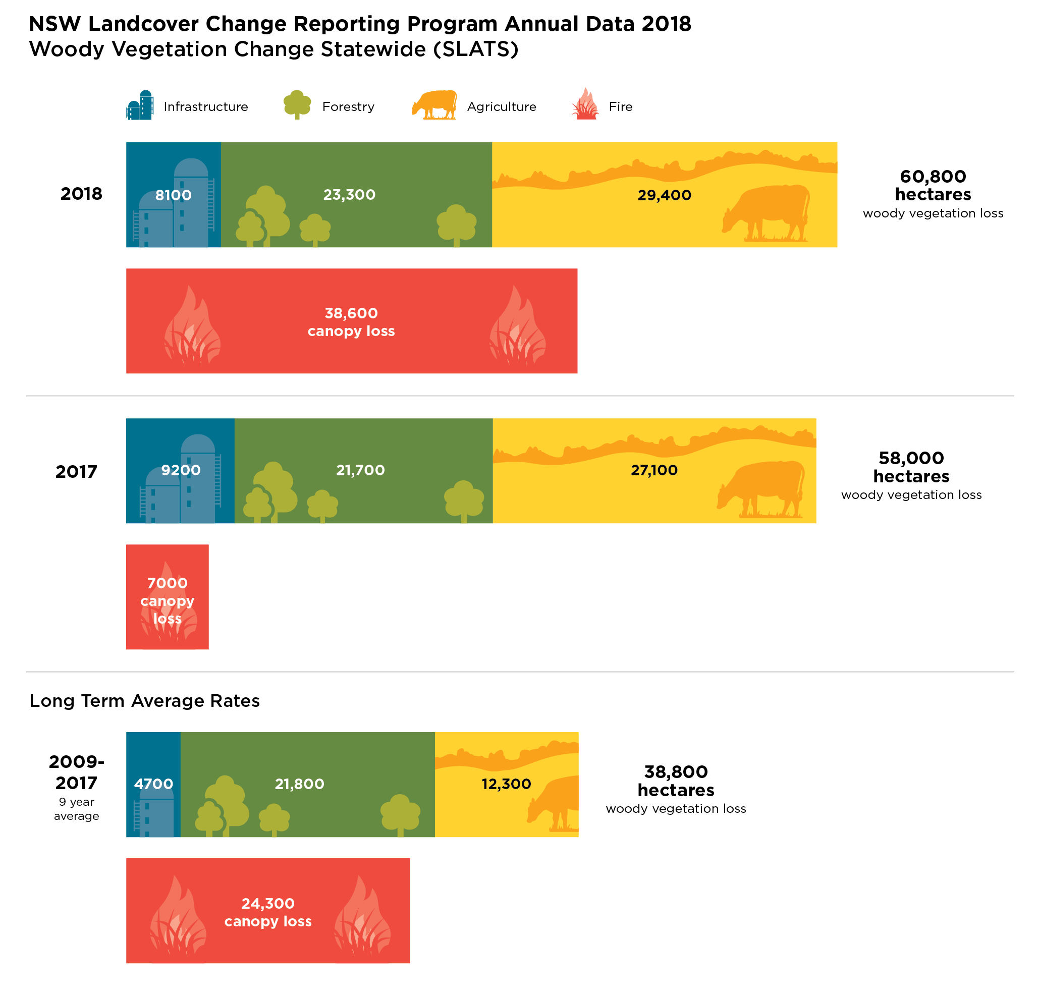
NSW Landcover Change Reporting Program Annual Data 2018: Woody Vegetation Change Statewide (SLATS)
2018 Data and Summary Report for Woody Vegetation Change in New South Wales
Summary Woody Vegetation Change Statewide SLATS 2018 (PDF 993KB)
Results Woody Vegetation Change Statewide (SLATS) 2018 (XLSX 758KB)
Part 2 – Landcover change on Rural Regulated Land in New South Wales
In 2018, approximately 42,000 hectares of non woody (grasses, small shrubs and groundcover) vegetation and 34,000 hectares of woody vegetation was lost on Rural Regulated Land. Data for Rural Regulated Land is being reported for the first time, representing that part of the state subject to the Local Land Services Act – Part 5A, which came into effect in August 2017.
Approximately 43 million hectares (54%) of land in New South Wales has been categorised as Rural Regulated Land and is subject to the provisions of the Land Management (Native Vegetation) Code 2018.
The Local Land Services Act 2013 provides for transitional arrangements for determining land categorisation. Until an area has been designated on the Native Vegetation Regulatory Map, landholders can self-assess groundcover (grasses, forbs and herbs) to determine the area’s regulatory status (Category 1 – Exempt land, or Category 2 – Regulated land). Landholder self-assessment of groundcover within the transitional mapping period will contribute to non woody vegetation cover change.
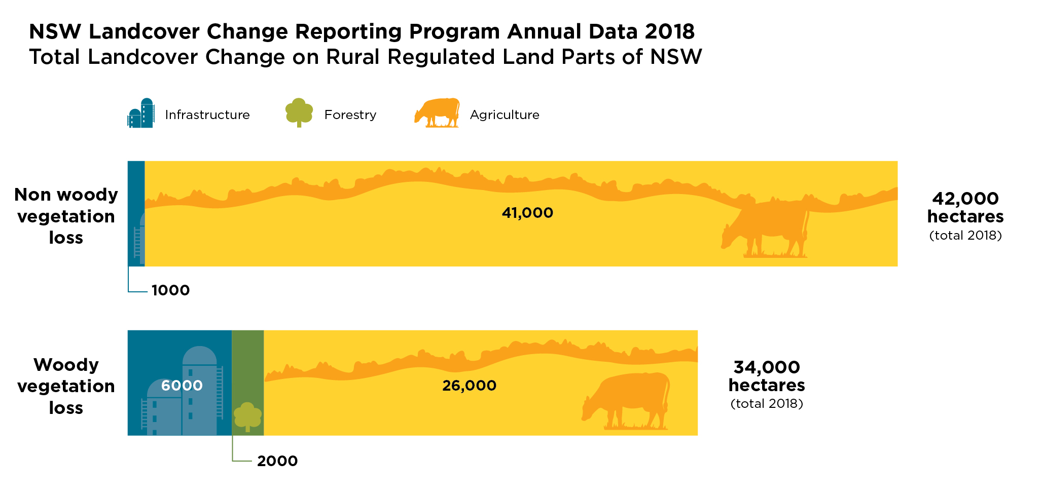
NSW Landcover Change Reporting Program Annual Data 2018: Total Landcover Change on Rural Regulated Land Parts of NSW
Clearing authorisation
Under the Local Land Services Act 2013, the aim of the Land management code is to:
(a) authorise clearing of native vegetation on Category 2-regulated land,
(b) provide for establishment and management of set aside areas, and
(c) authorise re-categorisation of land.
Of the landcover change detected in 2018, 20% was authorised under the previous legislative framework, 6% is attributed to authorisations under the Local Land Services Act 2013 and 73% is unexplained. Over 90% of non woody vegetation loss and 50% of woody vegetation loss was unexplained.
Within the landcover change figures, the majority of authorisations relate to activities such as managing invasive native species, woody regrowth and treating weed dominated groundcover.
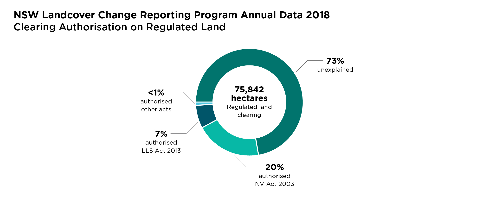
NSW Landcover Change Reporting Program 2018 – Clearing Authorisation on Regulated Land
Read more about unallocated clearing.
2018 Data and Summary Report for Rural Regulated Land in New South Wales
Summary Landcover Change Rural Regulated Land 2018 (PDF 305KB)
Results Landcover Change Rural Regulated Land 2018 (XLSX 127KB)