The Intersecting Streams arise in Queensland and flow across the border into New South Wales. These streams include the Narran, Bokhara, Culgoa, Warrego and Paroo rivers and key wetland systems including the Ramsar-listed Narran Lakes, Paroo Wetlands and Yantabulla Swamp. The river systems are located on a series of semi-arid floodplains and are fed by rainfall in the central and western areas of Queensland.
Flows in these river systems are intermittent and unregulated, and flow events are typically associated with southern summer monsoonal weather systems.
The focus of water managers in 2019–20, with an expected very dry to dry resource availability scenario as identified in the Intersecting Streams Catchment Annual Environmental Watering Priorities 2019–20, was to minimise unrecoverable loss of ecological assets and functionality.
Flows in early 2020
The 2019–20 water year was generally hot and dry. The Moonie, Culgoa, Narran, Birrie, Bokhara, and Paroo rivers experienced cease-to-flow conditions. Above average rainfall upstream of St George through February and March 2020 resulted in a large flow entering the Culgoa, Birrie, Bokhara and Narran rivers from the Lower Balonne.
These flows in the Intersecting Streams system in early 2020 included:
- flows generated from rainfall within Queensland that reached Narran Lakes in early March 2020, which included water from Commonwealth held environmental water in Queensland, providing the first significant water to the wetland system since 2013
- flows in the Paroo River that inundated parts of the Paroo Wetlands Ramsar site
- flows in the Warrego system that extended through Toorale National Park and State Conservation Area in late 2019 and from March 2020 – use of Commonwealth held environmental water produced flows into the Darling River and onto the western floodplain
- inflows into the Culgoa, Birrie, Bokhara and Moonie rivers in early 2020, which provided connection to the Barwon River.
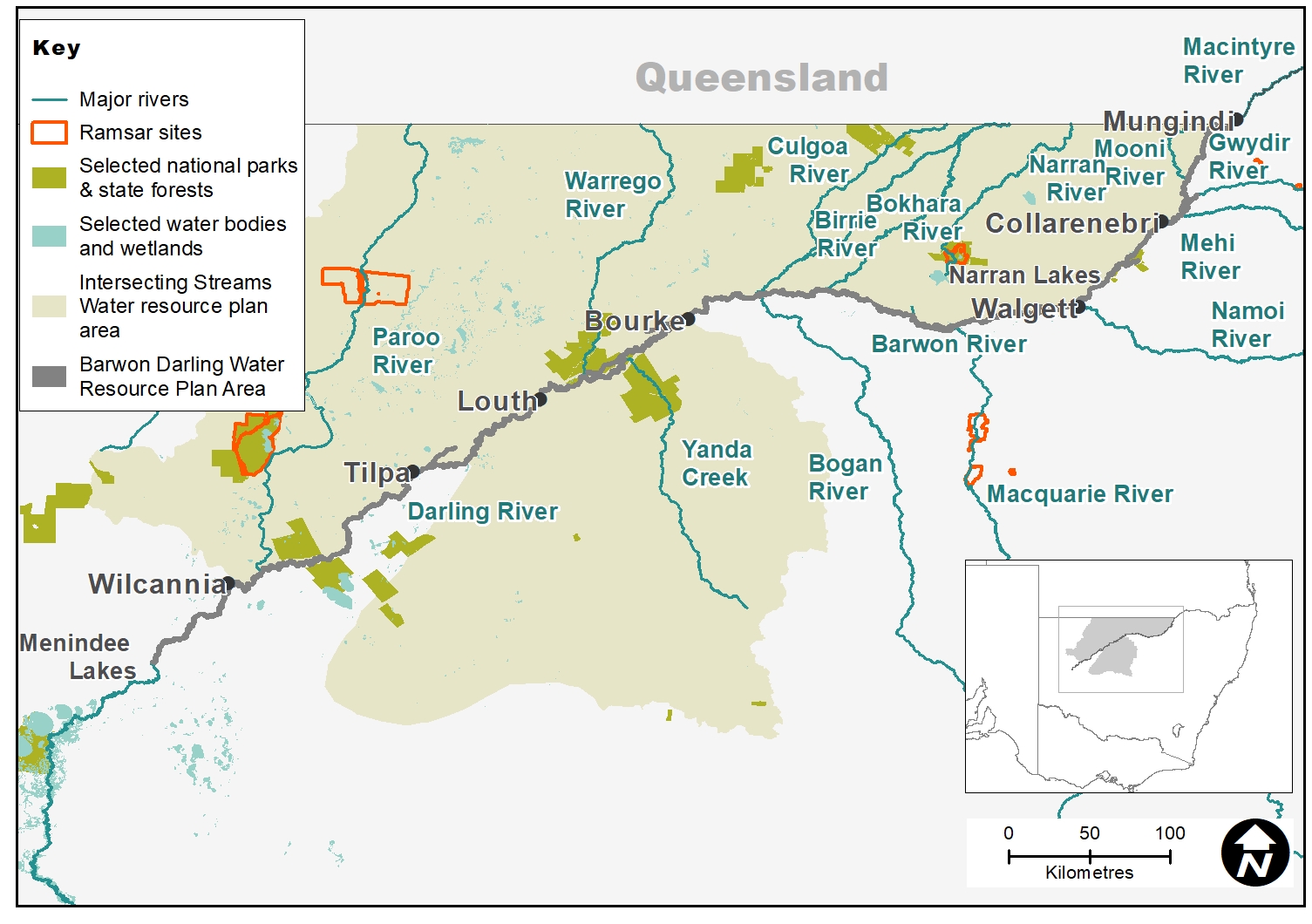
Map of the Intersecting Streams catchment showing waterways, wetlands and locations of water for the environment deliveries made in 2019–20.
Watering aims
The watering aims identified in the Intersecting Streams Annual Environmental Watering Priorities for the 2019–20 water year under dry to very dry conditions were assisted by wetter conditions in early 2020 that resulted in natural flows.
Unlike regulated catchments, the management of water for the environment in the Intersecting Streams catchment is largely reliant on improving outcomes from unregulated or natural flows in the rivers. The aim is to balance flows in the rivers to meet the needs of instream ecosystems and support floodplains and wetlands.
In 2019–20 the Commonwealth Environmental Water Holder identified priority actions to guide the management of their portfolio of water licenses for this system, subject to river flows.
In the Narran system licensed water entitlements aimed to:
- support replenishment flows to maintain habitat at Narran Lakes
- support flows to maintain and, where possible, improve habitat and support naturally triggered waterbird breeding
- support flows that replenish refuge waterholes for native fish in the Narran system.
In the Warrego system licensed water entitlements aimed to:
- supplement natural flows that provide connectivity between the Warrego and Barwon–Darling rivers
- balance water needs between the Warrego River floodplain and Darling River, facilitated by the operation of water management structures on Toorale National Park and State Conservation Area.
Outcomes
Due to extended dry conditions in the Intersecting Streams catchment, the Intersecting Streams Annual Environmental Watering Priorities 2019–20 (AEWP) did not expect connectivity to occur to the Darling River. If rainfall occurred and licenses were activated, the priorities of the AEWP were to:
- replenish waterholes for native fish habitat
- direct water to Narran Lake
- maintain extent, improve condition, and promote recruitment of vegetation in the catchment.
These priorities included all rivers within the Intersecting Streams catchment.
Between February and April 2020, a total of 1442 gigalitres flowed past St George in Queensland and into the Culgoa, Birrie, Bokhara and Narran rivers. This large inflow from the Balonne increased resilience and replenished habitat throughout the river systems. Traditional Owners who were monitoring the Narran Lakes suggested it was primed for a bird breeding event.
Rainfall in March 2020 activated the Commonwealth’s licenses for Toorale National Park and State Conservation Area (Toorale). The Commonwealth Environmental Water Holder contributed 16.2 gigalitres of the 45-gigalitre-flow that reached the Darling River from the Warrego.
More than 11,000 hectares of floodplain at and around Toorale was inundated. The flows connected the Darling River with the floodplain via the Talowla channel for the first time since 2010. NSW National Parks and Wildlife Service (NPWS) observed brolga chicks in the national park.
Unregulated Commonwealth entitlements in the Moonie River were activated in early 2020, contributing about 4.5 gigalitres of water for the environment.
Monitoring by the Murray–Darling Basin Authority, Commonwealth Environmental Water Office, and NPWS found that some AEWP outcomes were met in early 2020, including:
- replenishment of waterholes and refuges throughout the Intersecting Streams and the Barwon–Darling catchments
- significant inflows to Narran Lakes
- recovery of some ripharian and wetland vegetation.
Case study
Work on the Water Infrastructure Project at Toorale National Park and State Conservation Area (Toorale) has been ongoing throughout 2019–20, led by the Department of Planning, Industry and Environment.
The project involves removing, modifying or decommissioning existing water infrastructure on Toorale to support environmental outcomes.
The largest instream barrier on Toorale, Peebles Dam, was removed in October 2019. Floods down the Warrego River since then have flowed unimpeded through this reach to the Darling River.
The next stage of the project will involve modifications to infrastructure at Boera, Homestead and Booka dams.
Designs for Boera and Homestead dam works have been finalised and a comprehensive environmental assessment completed and approved.
The project involves modifications to 4 dams that were constructed across the Warrego River to support agricultural practices associated with the former Toorale Station. These dams were initially installed as part of property improvements during the late 19th century, primarily to increase floodplain watering and grazing capacity, and in later years store water for irrigation. Historic management of the flows on Toorale using the existing infrastructure has created high conservation value aquatic and wetland habitats. However, it has also reduced instream connectivity and created barriers to fish movement within this reach of the river. The aim of the project is to:
- increase water flow capacity through the lower reaches of the Warrego River and into the Darling River for downstream environmental benefits
- improve fish passage
- protect and maintain environmental, cultural and historic values.
For more information, visit the Toorale Water Infrastructure Project webpage.
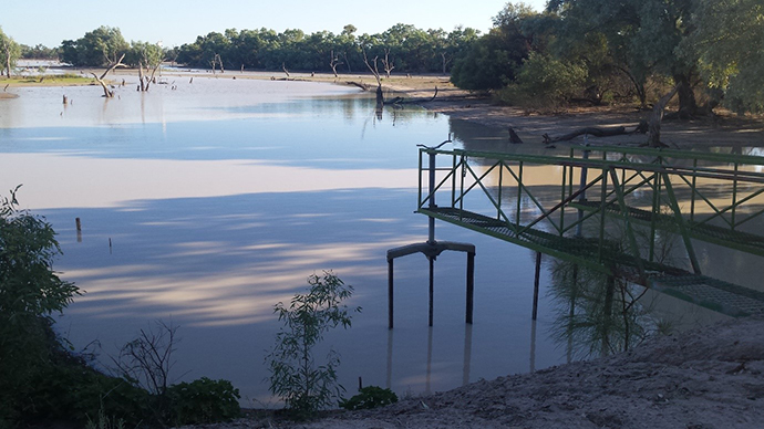
Boera Dam at Toorale