Waterbird breeding, strategic flow management and connectivity with the Barwon River were the focus of environmental flows in 2021–22.
Key outcomes
Under rapidly changing conditions, environmental water managers worked with partner agencies and stakeholders to coordinate the delivery of water for the environment in response to varying flows and dam spills. Actions aimed to:
- maintain water levels in colonial waterbird colony sites in the Macquarie Marshes
- support ongoing inundation within the Macquarie Marshes
- maintain flow connection to the Barwon River.
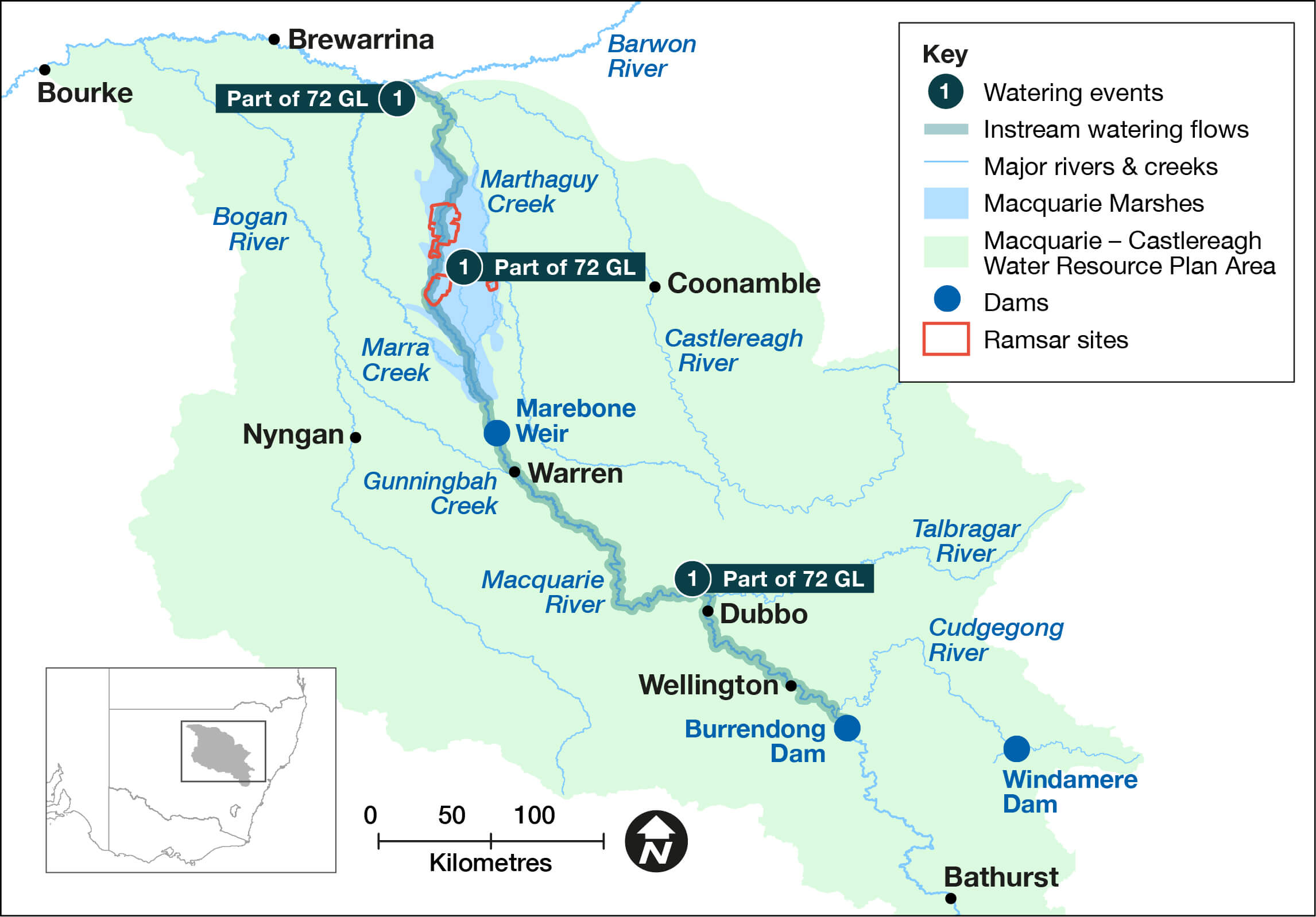
Map of sites in the Macquarie–Castlereagh catchment where environmental water was delivered in the 2021–22 water year, with corresponding volume.
Catchment conditions
During the 2021–22 year the Macquarie–Castlereagh catchment experienced various climate conditions, including La Niña weather conditions that produced wet conditions and generally cool temperatures.
Burrendong Dam began spilling in early September 2021 and rose to 145% in November 2021. Water allocations were reset to 100% on 1 December 2021, with the dam continuing to spill for the remainder of the water year. Changing conditions influenced the watering approach and outcomes sought.
About the catchment
The Macquarie–Castlereagh catchment is in central west New South Wales and covers an area of 75,000 square kilometres. Major rivers are the Castlereagh, Macquarie and Bogan, with major tributaries including the Cudgegong, Talbragar and Bell rivers. The catchment extends from the Blue Mountains to the Barwon River.
The Macquarie–Castlereagh catchment is home to the iconic Macquarie Marshes – one of the largest semi-permanent wetland systems and colonial waterbird breeding sites in inland Australia.
Traditional owners
The Macquarie-Castlereagh is the Country of the Wiradjuri, Ngiyampaa, Wailwan and Kamilaroi First Nations.
Watering aims
In May 2021, under a medium to wet scenario, the Macquarie–Cudgegong Environmental Water Advisory Group developed the Macquarie–Castlereagh Catchment – Water for the Environment Annual Priorities 2021–22. Objectives for the use of water for the environment focussed on actions in year 2 of a 3-year drought recovery plan, to:
- provide a large fresh at Marebone Weir during August and September 2021 to inundate a minimum of 9,000 hectares of the Macquarie Marshes
- deliver a flow of 800 to 1000 megalitres per day at Dubbo during October 2021 during the key known nesting time for Murray cod and eel-tailed catfish
- release a small fresh pulse in November 2021 to support the native fish hatching event, with a recession until December 2021.
With the water year resulting in favourable wet to very wet conditions, water managers used adaptive management strategies to restore key floodplain and wetland linkages, and enhance opportunities for plants and animals to breed, move and thrive.
Water delivery
This table and chart provide a summary of 71,512 megalitres of water for the environment delivered in the Macquarie–Castlereagh catchment during the 2021–22 watering year. This water complemented more than 1,200 gigalitres of tributary, flood mitigation and natural river flows as measured at Marebone Weir. Figures are accurate at the date of publishing, but maybe adjusted.
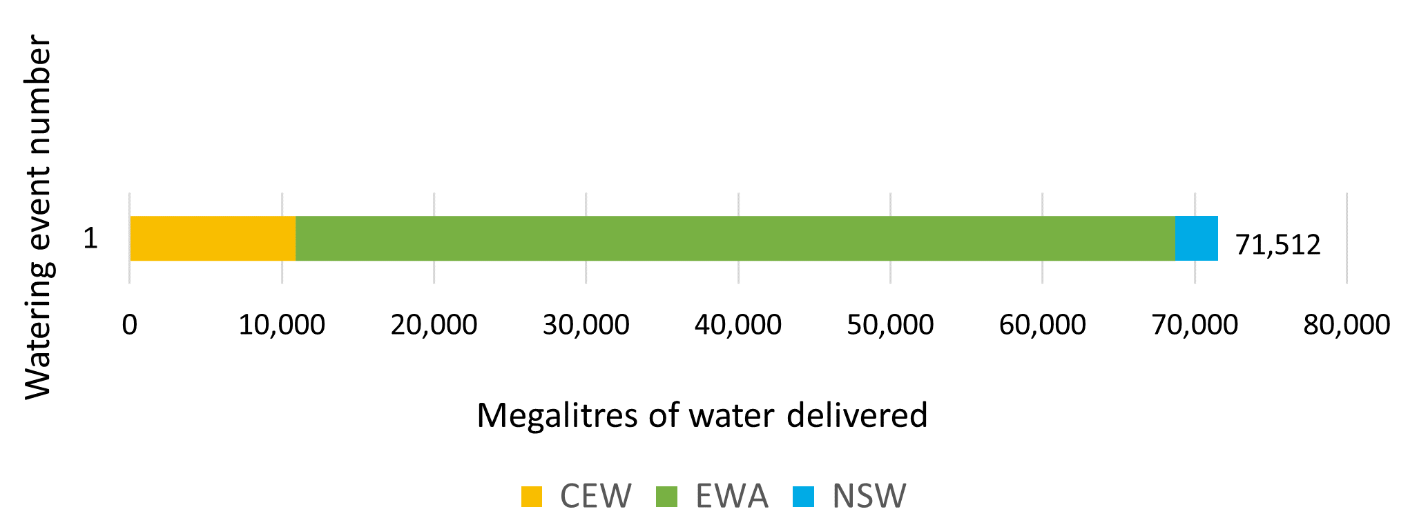
Notes: CEW = Commonwealth licensed environmental water; EWA = environmental water allowance accrued under the Water Sharing Plan; NSW = NSW licensed environmental water; TLM = The Living Murray.
| Watering event number | Location | Outcomes | Start date | Finish date |
|---|---|---|---|---|
| 1 | Macquarie | Waterbirds Vegetation Native fish Connectivity | 29 Jul 2021 | 5 May 2021 |
Outcomes
In 2021–22 NSW environmental water managers worked with and the Macquarie–Cudgegong Environmental Water Advisory Group and the Commonwealth Environmental Water Holder to adaptively manage water to achieve agreed drought-recovery outcomes. This included working with flood mitigation operations of Burrendong Dam and significant tributary inflows as the catchment became significantly wetter during the water year.
Remote sensing data for the Macquarie Marshes indicated well over 100,000 hectares was inundated during December 2021, including many of the outer areas not inundated since 2016. The extent of inundation was measured at around 193,000 hectares, close to the 2000–01 summer total extent.
This inundation and related rainfall drove colonial waterbird breeding. Large-scale waterbird colonies formed over spring 2021, and increased dramatically in size in December 2021 for completion in late summer and early autumn 2022. This included 3 large-scale ibis colonies of 30,000 to 40,000 nests, and several large-scale (5,000+ nests) night heron and egret colonies in river red gum areas. A range of smaller colonies across the marshes was also recorded.
River flows to the Barwon River occurred throughout the water year. This was driven by various river systems including the Bogan, Castlereagh, and Macquarie and resulted in benefits such as:
- system connectivity
- fish migration
- exchange of genetic materials
- supply of water to downstream catchments.
Case study: Summer of basin-wide colonial waterbird breeding extends to the Macquarie
Burrendong Dam began spilling in spring 2021 following strong catchment rainfall. Burrendong Dam has space for flood mitigation, which is managed by Water NSW to minimise the risk of flooding and, where relevant, to fulfil environmental outcomes.
The same rainfall created conditions for a range of colonial waterbirds to start breeding in the Macquarie Marshes. This was a critical season for breeding as long-term aerial surveys indicated ongoing population decline of many waterbird species. The last large-scale colonial breeding events in the Macquarie Marshes were in 2011 and 2016.
Large-scale waterbird colonies were recorded across all 3 subsystems of the Marshes, including 3 ibis colonies of 30,000 to 40,000 nests each, and several large-scale (5,000+ nest) night heron and egret colonies in river red gum forests. Many smaller colonies were also recorded.
We assisted Water NSW in operational planning for the Burrendong flood mitigation zone. Monitoring information was supplied to inform water level targets within the Marshes, allowing the dam releases to support colonial waterbirds to complete their breeding in autumn 2022.
We also conducted ground and aerial monitoring during the breeding events in collaboration with the University of NSW and CSIRO. This work indicated the colonies were quite successful, with all known large-scale colonies completing their life cycle. CSIRO tracking indicated some breeding adult birds foraged in the lower Castlereagh catchment, some 80 kilometres away. A number of birds were caught and tagged for post-colony satellite tracking by CSIRO.
We thank the land managers of the Macquarie Marshes, the CEWH for their monitoring resourcing assistance, monitoring partners University of NSW and CSIRO, and Water NSW for working with us to support this important breeding event.
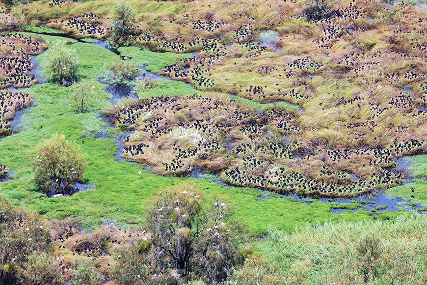
Large-scale waterbird colonies were recorded across all 3 subsystems of the Macquarie Marshes.